Our website is made possible by displaying online advertisements to our visitors.
Please consider supporting us by disabling your ad blocker.
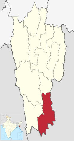
Siaha district
Siaha district | |
|---|---|
 View of Siaha from Tlapi Viewpoint | |
 Location in Mizoram | |
| Country | India |
| State | Mizoram |
| Headquarters | Siaha |
| Government | |
| • Lok Sabha constituencies | Mizoram |
| • Vidhan Sabha constituencies | 2 |
| Area | |
| 1,400 km2 (500 sq mi) | |
| Population (2011) | |
| 56,574 | |
| • Density | 40/km2 (100/sq mi) |
| • Urban | 25,110 (44.38%) |
| Demographics | |
| • Literacy | 90.01 |
| • Sex ratio | 979 |
| Time zone | UTC+05:30 (IST) |
| Website | siaha |
Siaha district is one of the eleven districts of Mizoram state in India. The district is bounded on the northwest by Lunglei district, on the north and west by Lawngtlai District and on the south and east by Myanmar. The district occupies an area of 1399.9 km2. Siaha town is the administrative headquarters of the Mara Autonomous District Council. The population had Increased from 56,574 (in 2011 census) to 67,658 (in 2021) [citation needed]. It is the least populous district of Mizoram (out of 8).[1]
- ^ "District Census 2011". Census2011.co.in. 2011. Retrieved 30 September 2011.
Previous Page Next Page


