Our website is made possible by displaying online advertisements to our visitors.
Please consider supporting us by disabling your ad blocker.
Siege of Kamarja
| Siege of Kamarja | |||||||
|---|---|---|---|---|---|---|---|
| Part of the Muslim conquest of Transoxiana | |||||||
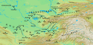
 Map of Khurasan and Transoxiana in the 8th century | |||||||
| |||||||
| Belligerents | |||||||
| Umayyad Caliphate |
Türgesh Khaganate Allied Soghdian princes | ||||||
| Commanders and leaders | |||||||
| Unknown | Suluk | ||||||
The siege of Kamarja was fought in 729 between the Arab Muslims of the Umayyad Caliphate and the Türgesh Khaganate, along with its Soghdian allies. The Umayyad conquest of Transoxiana had been undone in the 720s by the uprisings of the local Soghdian princes and the Türgesh invasions. By 729, the small fortress of Kamarja near Samarkand (in modern Uzbekistan) was one of the last remaining Arab strongholds in Transoxiana, when it was attacked by the Türgesh under the personal direction of their ruler, Suluk. The subsequent siege, for which a detailed account survives in the history of al-Tabari, lasted for 58 days and ended with the negotiated withdrawal of its garrison to Samarkand. The stubborn defence of Kamarja was celebrated in Arabic literature, but the Arab hold over the region was broken after the Battle of the Defile two years later. It was only following the collapse of the Türgesh Khaganate after 738 that the Arabs re-established their rule over Transoxiana.
Previous Page Next Page


