Our website is made possible by displaying online advertisements to our visitors.
Please consider supporting us by disabling your ad blocker.
Sint-Truiden
This article needs additional citations for verification. (January 2013) |
Sint-Truiden
Sintruin (Limburgish) Saint-Trond (French) | |
|---|---|
City and municipality | |
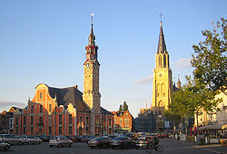
 Market Square with eighteenth-century City Hall, Church of Our Lady and abbey tower | |
| Coordinates: 50°48′N 05°11′E / 50.800°N 5.183°E | |
| Country | |
| Community | Flemish Community |
| Region | Flemish Region |
| Province | Limburg |
| Arrondissement | Hasselt |
| Government | |
| • Mayor | Ingrid Kempeneers (CD&V) |
| • Governing party/ies | CD&V, Open VLD, N-VA |
| Area | |
• Total | 107.12 km2 (41.36 sq mi) |
| Population (2020-01-01)[1] | |
• Total | 40,672 |
| • Density | 380/km2 (980/sq mi) |
| Postal codes | 3800, 3803, 3806 |
| NIS code | 71053 |
| Area codes | 011 |
| Website | www.sint-truiden.be |
Sint-Truiden (Dutch pronunciation: [sɪnˈtrœydə(n)] ⓘ; French: Saint-Trond [sɛ̃ tʁɔ̃]; Limburgish: Sintruin [sɪnˈtʀœjn])[tone?] is a city and municipality located in the province of Limburg, Flemish Region, Belgium. With more than 41,500 inhabitants, it is one of the largest cities in Limburg.
The municipality includes the former communes (now deelgemeenten) of Aalst, Brustem, Duras, Engelmanshoven, Gelinden, Gorsem, Groot-Gelmen, Halmaal, Kerkom-bij-Sint-Truiden, Melveren, Metsteren, Ordingen, Runkelen, Velm, Wilderen, and Zepperen.
The city is in the centre of Belgium's fruit-producing region, Haspengouw (Hesbaye), which is renowned for its pears, apples (Jonagold), and sweet cherries.
Previous Page Next Page


