Our website is made possible by displaying online advertisements to our visitors.
Please consider supporting us by disabling your ad blocker.
Sluch (Ukraine)
This article needs additional citations for verification. (April 2019) |
| Sluch | |
|---|---|
 Sluch River near Hubkiv | |
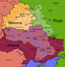
 Sluch River (shown crossing light purple region) | |
 | |
| Native name | Случ (Ukrainian) |
| Location | |
| Country | Ukraine |
| Physical characteristics | |
| Source | |
| • location | Khmelnytskyi Oblast, Ukraine |
| Mouth | Horyn |
• coordinates | 51°38′15″N 26°38′45″E / 51.6376°N 26.6457°E |
| Length | 451 km (280 mi) |
| Basin size | 13,800 km2 (5,300 sq mi) |
| Basin features | |
| Progression | Horyn→ Pripyat→ Dnieper→ Dnieper–Bug estuary→ Black Sea |
The Sluch or Southern Sluch (Ukrainian: Случ; Russian: Случь, Южная Случь; Polish: Słucz; Czech: Sluč, Jižní Sluč) is a river in Ukraine. It is a right tributary of the Horyn. It has a length of 451 kilometres (280 mi) and a drainage basin of 13,800 square kilometres (5,300 sq mi).[1] The Sluch takes its source in the Ukrainian oblast of Khmelnytskyi. It then flows through the Zhytomyr and Rivne oblasts, and briefly along the Ukrainian-Belarusian border before finally emptying into the Horyn.[2][3][1][4]
Cities and towns located on the Sluch river include: Zviahel, Berezne, and Sarny.
- ^ a b "Случь (река, приток р. Горынь)" (in Russian). Большая Советская Энциклопедия. Retrieved 2019-04-20.
- ^ Izsák Tibor (2007). Ukrajna természeti földrajza (pdf) (in Hungarian). II. Rákóczi Ferenc Kárpátaljai Magyar Főiskola. p. 95. Retrieved 2019-04-20.
- ^ "NÉVJEGYZÉK-SZÓTÁR az UKRAJNA TERMÉSZETI FÖLDRAJZA tantárgyhoz" (pdf) (in Hungarian). II. Rákóczi Ferenc Kárpátaljai Magyar Főiskola. Retrieved 2019-04-20.
- ^ "Sluch River". Encyclopedia of Ukraine. Retrieved 2019-04-23.
Previous Page Next Page


