Our website is made possible by displaying online advertisements to our visitors.
Please consider supporting us by disabling your ad blocker.
South Sinai Governorate
South Sinai Governorate | |
|---|---|
 Landscape in South Sinai governorate | |
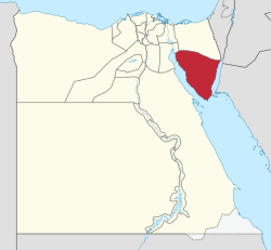
 South Sinai Governorate on the map of Egypt | |
| Coordinates: 29°03′N 33°50′E / 29.05°N 33.83°E | |
| Country | |
| Seat | El Tor (capital) |
| Government | |
| • Governor | Khaled Fouda Saddiq Mohammed[1] |
| Area | |
• Total | 33,140 km2 (12,800 sq mi) |
| Population (January 2024)[2] | |
• Total | 117,113 |
| • Density | 3.5/km2 (9.2/sq mi) |
| GDP | |
| • Total | EGP 58 billion (US$ 3.7 billion) |
| Time zone | UTC+2 (EET) |
| ISO 3166 code | EG-JS |
| HDI (2021) | 0.738[4] high · 10th |
| Website | www |
South Sinai Governorate (Arabic: محافظة جنوب سيناء Muḥāfaẓah Ganūb Sīnāʾ) is the least populated governorate of Egypt. It is located in the east of the country, encompassing the southern half of the Sinai Peninsula. Saint Catherine's Monastery, an Eastern Orthodox Church monastery and UNESCO World Heritage Site of world renown, is located in the central part of the governorate.
- ^ "رسمياً.. المحافظون الجدد ونوابهم يؤدون اليمين الدستورية أمام الرئيس". Almasry Alyoum (in Arabic). 30 August 2018. Archived from the original on 31 August 2018. Retrieved 31 August 2018.
- ^ Cite error: The named reference
CAPMAS2023was invoked but never defined (see the help page). - ^ "GDP BY GOVERNORATE". mped.gov.eg.
- ^ "Sub-national HDI - Subnational HDI - Table - Global Data Lab". globaldatalab.org. Retrieved 20 February 2023.
Previous Page Next Page


