Our website is made possible by displaying online advertisements to our visitors.
Please consider supporting us by disabling your ad blocker.
St Julians, Newport
| St Julians | |
|---|---|
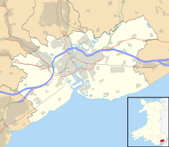
Location within Newport | |
| Population | 8,675 (2011 census)[1] |
| OS grid reference | ST322894 |
| Principal area | |
| Country | Wales |
| Sovereign state | United Kingdom |
| Post town | NEWPORT |
| Postcode district | NP19 7 |
| Dialling code | 01633 |
| Police | Gwent |
| Fire | South Wales |
| Ambulance | Welsh |
| UK Parliament | |
| Senedd Cymru – Welsh Parliament | |
St Julians (Welsh: Sain Silian) is a community and coterminous electoral district (ward) of the City of Newport, South Wales.
The community is bounded by the River Usk to the west and north, The Moorings, Badminton Road, Reynolds Close, Rembrandt Way, Constable Drive, Heather Road, Kelly Road, Merlin Crescent, Avalon Drive, across St Julian's Road and Norfolk Road to the east, Christchurch Road, Church Road, Clarence Place and Newport Bridge to the south. The ward includes the districts of Barnardtown, Riverside, and most of St. Julians (the rest being in Beechwood ward).
- ^ "Newport ward 2011". Retrieved 5 April 2015.
Previous Page Next Page


