Our website is made possible by displaying online advertisements to our visitors.
Please consider supporting us by disabling your ad blocker.
Stockton Springs, Maine
Stockton Springs, Maine | |
|---|---|
 | |
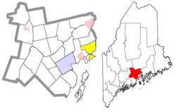
 Location of Stockton Springs (in yellow) in Waldo County and the state of Maine | |
| Coordinates: 44°29′36″N 68°50′55″W / 44.49333°N 68.84861°W | |
| Country | United States |
| State | Maine |
| County | Waldo |
| Incorporated | 1857 |
| Area | |
• Total | 29.83 sq mi (77.26 km2) |
| • Land | 19.64 sq mi (50.87 km2) |
| • Water | 10.19 sq mi (26.39 km2) |
| Elevation | 89 ft (27 m) |
| Population (2020) | |
• Total | 1,533 |
| • Density | 78/sq mi (30.1/km2) |
| Time zone | UTC−5 (Eastern (EST)) |
| • Summer (DST) | UTC−4 (EDT) |
| ZIP Code | 04981 |
| Area code | 207 |
| FIPS code | 23-74475 |
| GNIS feature ID | 0582749 |
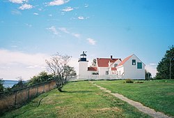
Stockton Springs is a town in Waldo County, Maine, United States. The population was 1,533 at the 2020 census.[2] Stockton Springs is home to Fort Point State Park and Fort Point Light, both located on Fort Point, a peninsula on Cape Jellison.
- ^ Cite error: The named reference
Gazetteer fileswas invoked but never defined (see the help page). - ^ "Census - Geography Profile: Stockton Springs town, Waldo County, Maine". Retrieved January 19, 2022.
Previous Page Next Page


