Our website is made possible by displaying online advertisements to our visitors.
Please consider supporting us by disabling your ad blocker.
Stones River
| Stones River | |
|---|---|
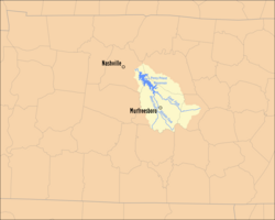
 Map of the Stones River Watershed | |
 | |
| Location | |
| Country | United States |
| Physical characteristics | |
| Source | |
| • location | East Fork – Short Mountain (Cannon County) Middle Fork – Hoovers Gap (Rutherford County) West Fork – Tennessee Valley Divide (Rutherford County) |
| • elevation | East Fork - 1,120 feet (341.4 m) Middle Fork - 923 feet (281.3 m) West Fork - 792 feet (241.4 m) |
| Mouth | |
• location | Cumberland River near Nashville |
• coordinates | 36°11′30″N 86°39′45″W / 36.19167°N 86.66250°W[1] |
• elevation | 413 feet (125.9 m)[1] |
| Length | Main River - 32.4 miles (52.1 km) East Fork - 54.0 miles (86.9 km) Middle Fork - 19.8 miles (31.9 km) West Fork - 39.1 miles (62.9 km) |
| Basin size | 921 square miles (2,385.4 km2) |
The Stones River (properly spelled Stone's River)[2] is a major stream of the eastern portion of Tennessee's Nashville Basin region[1] and a tributary of the Cumberland River. It is named after explorer and longhunter Uriah Stone, who navigated the river in 1767.[3][4]
- ^ a b c U.S. Geological Survey Geographic Names Information System: Stones River
- ^ Stones River History
- ^ Collins, Lewis (1877). History of Kentucky. p. 417.
- ^ Name: Uriah Stone?
Previous Page Next Page


