Our website is made possible by displaying online advertisements to our visitors.
Please consider supporting us by disabling your ad blocker.
Sturry
This section needs additional citations for verification. (July 2019) |
| Sturry | |
|---|---|
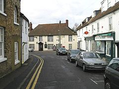
 Sturry High Street | |
Location within Kent | |
| Area | 13.42 km2 (5.18 sq mi) |
| Population | 6,820 (Civil Parish 2011Y)[1] |
| • Density | 508/km2 (1,320/sq mi) |
| OS grid reference | TR176606 |
| Civil parish |
|
| District | |
| Shire county | |
| Region | |
| Country | England |
| Sovereign state | United Kingdom |
| Post town | CANTERBURY |
| Postcode district | CT2, CT3 |
| Dialling code | 01227 |
| Police | Kent |
| Fire | Kent |
| Ambulance | South East Coast |
| UK Parliament | |
Sturry is a village on the Great Stour river situated 3 miles (4.8 km) northeast of Canterbury in Kent. Its large civil parish incorporates several hamlets and, until April 2019, the former mining village of Hersden.[2]
- ^ Key Statistics; Quick Statistics: Population Density Archived 11 February 2003 at the Wayback Machine United Kingdom Census 2011 Office for National Statistics Retrieved 21 November 2013
- ^ "Sturry Parish Council". Retrieved 10 December 2020.
Previous Page Next Page


