Our website is made possible by displaying online advertisements to our visitors.
Please consider supporting us by disabling your ad blocker.
Sultanpur district
Sultanpur district | |
|---|---|
 House in Sultanpur | |
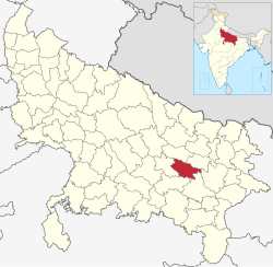
 Location of Sultanpur district in Uttar Pradesh | |
| Coordinates (Sultanpur, Uttar Pradesh): 26°15′N 82°00′E / 26.250°N 82.000°E | |
| Country | India |
| State | Uttar Pradesh |
| Division | Ayodhya |
| Headquarters | Sultanpur |
| Tehsils | Lambhua, Kadipur, Sultanpur, Jaisinghpur, Baldirai |
| Government | |
| • Lok Sabha constituencies | Sultanpur |
| • Vidhan Sabha constituencies | 5 |
| Area | |
• Total | 2,672.89 km2 (1,032.01 sq mi) |
| Population (2011)[1] | |
• Total | 2,249,036 |
| • Density | 840/km2 (2,200/sq mi) |
| • Urban | 146,892 |
| Time zone | UTC+05:30 (IST) |
| Vehicle registration | UP-44 |
| Website | sultanpur |
Sultanpur district is a district in the Awadh region of the Indian state of Uttar Pradesh. This district is a part of Ayodhya division of the state. The administrative headquarters of the district is Sultanpur city. The total area of Sultanpur district is 2672.89 Sq. km.[2]
As of 2011, Sultanpur district has a population of 2,249,036 people.[1]
- ^ a b "District Sultanpur Digital India". sultanpur.nic.in. Retrieved 3 April 2022.
- ^ "District Sultanpur, Government of Uttar Pradesh | The Land of Maharaja Kush | India". Retrieved 8 March 2021.
Previous Page Next Page


