Our website is made possible by displaying online advertisements to our visitors.
Please consider supporting us by disabling your ad blocker.
Sunda Kelapa
| Port of Sunda Kelapa | |
|---|---|
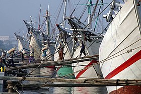
 Pinisi line up at Sunda Kelapa | |
 Click on the map for a fullscreen view | |
| Location | |
| Country | |
| Location | North Jakarta, Indonesia |
| Coordinates | 6°07′26″S 106°48′31″E / 6.123871°S 106.80861°E |
| Details | |
| Operated by | Indonesia Port Corporations |
| Type of harbour | Natural seaport |
| Land area | 50.8 Ha |
| Statistics | |
| Vessel arrivals | Hourly |
| Website www | |

Sunda Kelapa (Sundanese: ᮞᮥᮔ᮪ᮓ ᮊᮜᮕ, Sunda Kalapa) is the old port of Jakarta, located on the estuary of the Ciliwung River. "Sunda Kalapa" (Sundanese: "Coconut of Sunda") is the original name, and it was the main port of the Sunda Kingdom. The port is situated in Penjaringan District, of North Jakarta, Indonesia. Today the old port only accommodates pinisi, a traditional two-masted wooden sailing ship providing inter-island freight service in the archipelago. Although it is now only a minor port, Jakarta has its origins in Sunda Kelapa and it played a significant role in the city's development. The port is currently operated by the state-owned Indonesia Port Corporations.
Previous Page Next Page


