Our website is made possible by displaying online advertisements to our visitors.
Please consider supporting us by disabling your ad blocker.
Sutton Bridge, Oxfordshire
Sutton Bridge | |
|---|---|
 Sutton Bridge | |
| Coordinates | 51°39′00″N 1°15′57″W / 51.649923°N 1.265848°W |
| Carries | Minor road |
| Crosses | River Thames |
| Locale | Sutton Courtenay, Oxfordshire |
| Maintained by | Oxfordshire County Council |
| Heritage status | Grade II listed |
| Characteristics | |
| Design | arch |
| Material | Stone |
| Height | 14 feet 9 inches (4.50 m)[1] |
| No. of spans | 5 & 1 |
| Piers in water | 2 |
| History | |
| Opened | 1807 |
| Location | |
 | |
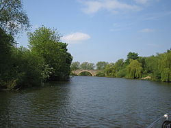
Sutton Bridge is a road bridge across the River Thames near the village of Sutton Courtenay, Oxfordshire, England. It is a stone structure built in 1807 with three arches over the main river and two smaller ones across the flood plain. An extension was built in 1809 across the Culham Cut, just below Culham Lock. It was originally a toll bridge and replaced an earlier multi-arch bridge over the original weir and a ferry at this site.[2] It is a Grade II listed building.[3]
- ^ River Thames Alliance. Bridge heights on the River Thames.
- ^ Thacker, Fred. S. (1968) [1920]. The Thames Highway: Volume II Locks and Weirs. Newton Abbot: David and Charles. pp. 167, 171.
- ^ Historic England. "SUTTON BRIDGE AND CAUSEWAYS (1182464)". National Heritage List for England. Retrieved 18 June 2015.
Previous Page Next Page


