Our website is made possible by displaying online advertisements to our visitors.
Please consider supporting us by disabling your ad blocker.
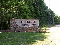
T. O. Fuller State Park
| T.O. Fuller State Park | |
|---|---|
 T.O. Fuller State Park Memphis TN | |
 | |
| Type | Tennessee State Park |
| Location | Memphis, Shelby County, Tennessee |
| Coordinates | 35°03′35″N 90°06′51″W / 35.0597°N 90.1142°W |
| Area | 1,138 acres (461 ha) |
| Operated by | TDEC |
| Website | T.O. Fuller State Park |
T.O. Fuller State Park is a state park in the city of Memphis, Tennessee, USA. It consists of 1,138 acres (461 ha) of mostly forest located in South Memphis on Mitchell Road. It is the only state park within the city limits and is suitable for wildlife.
The park is named in honor of Dr. Thomas O. Fuller, who spent his life empowering and educating African Americans.[1] The park facilities were originally built for the use of African Americans in the Great Depression by the Civilian Conservation Corps (CCC). It was the first state park in the United States east of the Mississippi River that was open to African Americans.[2]
CCC camp number 1464-SP-10, which was composed of African Americans, initiated construction of the park facilities in 1938. During excavation for a proposed swimming pool in 1940, CCC workers unearthed evidence of a prehistoric village. The site has since been developed as Chucalissa Indian Village and includes a village, preserved archeological excavations and the C.H. Nash Museum at Chucalissa.[3]
- ^ Carroll Van West, "Thomas Oscar Fuller.", Tennessee Encyclopedia of History and Culture.
- ^ "T.O. Fuller State Park — Tennessee State Parks". Tennessee State Parks. December 20, 2016. Archived from the original on December 20, 2016. Retrieved June 11, 2019.
- ^ Tennessee Department of Environment & Conservation pamphlet: authorization no. 327152 (July 2009)
Previous Page Next Page


