Our website is made possible by displaying online advertisements to our visitors.
Please consider supporting us by disabling your ad blocker.
Takatsu-ku, Kawasaki
You can help expand this article with text translated from the corresponding article in Japanese. (March 2016) Click [show] for important translation instructions.
|
Takatsu
高津区 | |
|---|---|
| Takatsu Ward | |
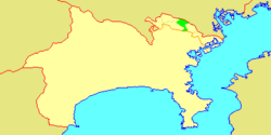
 Location of Takatsu in Kanagawa | |
| Coordinates: 35°35′58″N 139°36′29″E / 35.59944°N 139.60806°E | |
| Country | Japan |
| Region | Kantō |
| Prefecture | Kanagawa |
| City | Kawasaki |
| Established | April 1, 1972 |
| Area | |
• Total | 16.38 km2 (6.32 sq mi) |
| Population (March 2010) | |
• Total | 215,158 |
| • Density | 13,150/km2 (34,100/sq mi) |
| Time zone | UTC+9 (Japan Standard Time) |
| - Tree | Ume |
| - Flower | Narcissus |
| Address | 2-8-1 Shimosakunobe, Takatsu-ku Kawasaki-shi, Kanagawa-ken 213-8570 |
| Website | Takatsu Ward Office |

Takatsu-ku (高津区) is one of the 7 wards of the city of Kawasaki in Kanagawa Prefecture, Japan. As of 2010, the ward had an estimated population of 215,158 and a density of 13,150 persons per km². The total area is 16.38 km².
Previous Page Next Page


