Our website is made possible by displaying online advertisements to our visitors.
Please consider supporting us by disabling your ad blocker.
Talihina, Oklahoma
Talihina, Oklahoma
Tʋli Hina (Choctaw) | |
|---|---|
Town | |
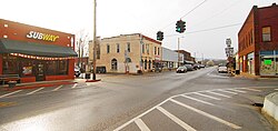
 historic downtown Talihina | |
 Location of Talihina, Oklahoma | |
| Coordinates: 34°45′09″N 95°02′37″W / 34.75250°N 95.04361°W | |
| Country | United States |
| State | Oklahoma |
| County | LeFlore County |
| Area | |
• Total | 1.00 sq mi (2.58 km2) |
| • Land | 0.99 sq mi (2.57 km2) |
| • Water | 0.01 sq mi (0.02 km2) |
| Elevation | 692 ft (211 m) |
| Population (2020) | |
• Total | 925 |
| • Density | 933.40/sq mi (360.25/km2) |
| Time zone | UTC-6 (Central (CST)) |
| • Summer (DST) | UTC-5 (CDT) |
| FIPS code | 40-72250[3] |
| GNIS feature ID | 2413363[2] |
| Website | http://www.talihinacc.com |
Talihina (pronounced "tah-luh-HEE-nuh") is a town in LeFlore County, Oklahoma, United States, its name originating from two Choctaw words, tully and hena, meaning "iron road," a reference to the railroad around which the town was built.[4] It is part of the Fort Smith, Arkansas–Oklahoma Metropolitan Statistical Area. The population was 925 at the time of the 2020 Census.[5]
- ^ "ArcGIS REST Services Directory". United States Census Bureau. Retrieved September 20, 2022.
- ^ a b U.S. Geological Survey Geographic Names Information System: Talihina, Oklahoma
- ^ "U.S. Census website". United States Census Bureau. Retrieved January 31, 2008.
- ^ Cox, Michael S. Encyclopedia of Oklahoma History and Culture. "Talihina" Retrieved March 6, 2015. [1].
- ^ "Talihina (town), Oklahoma". United States Census Bureau. Retrieved June 13, 2023.
Previous Page Next Page


