Our website is made possible by displaying online advertisements to our visitors.
Please consider supporting us by disabling your ad blocker.
Tamanrasset Province
Tamanrasset Province
ولاية تمنراست | |
|---|---|
| Province of Tamanrasset | |
 | |
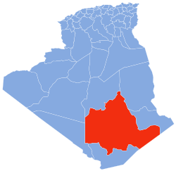
 Map of Algeria highlighting Tamanrasset | |
| Coordinates: 22°47′N 05°31′E / 22.783°N 5.517°E | |
| Country | |
| Founded | July 2, 1974 |
| Capital | Tamanrasset |
| Government | |
| • Governor | Mohamed Boudras |
| Area | |
• Total | 336,839 km2 (130,054 sq mi) |
| • Rank | 1st |
| Elevation | 1,400 m (4,600 ft) |
| Highest elevation | 3,303 m (10,837 ft) |
| Population (2008)[2] | |
• Total | 115,043 (within current boundaries) |
| • Rank | 50th |
| • Density | 0.206/km2 (0.53/sq mi) |
| Time zone | UTC+01 (CET) |
| Area Code | +213 (0) 29 |
| ISO 3166 code | DZ-11 |
| Districts | 3 |
| Municipalities | 5 |
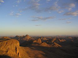
Tamanrasset or Tamanghasset (Arabic: ولاية تمنراست Wilāya Tamanrāssat, Berber languages: ⵜⵣ'ⵓⵏⵜ ⵏ ⴰⴾⴰⵍ ⵜⴰⵏ ⵜⴰⵎⴰⵏⵗⴰⵙⵜ) is a province (wilaya) in southern Algeria. It is named after its province seat, Tamanrasset. The province is the home of two national parks: Ahaggar National Park and Tassili n'Ajjer National Park. It is the largest province in Algeria, with an area of 336,839 km2.
- ^ Ighil, Ravah (1 Feb 2017). "L'Ecole de police livrée avant juin 2017". El Watan (in French). Retrieved 21 Jul 2022.
- ^ Office National des Statistiques, Recensement General de la Population et de l’Habitat 2008 Archived 2008-07-24 at the Wayback Machine Preliminary results of the 2008 population census. Accessed on 2008-07-02.
Previous Page Next Page


