Our website is made possible by displaying online advertisements to our visitors.
Please consider supporting us by disabling your ad blocker.
Tanegashima
Native name: 種子島 | |
|---|---|
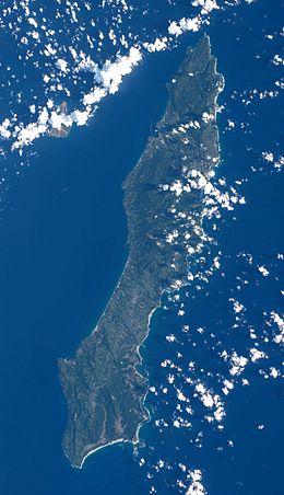
 NASA photo of Tanegashima | |
 Tanegashima is the easternmost of the Ōsumi Islands, just south of the major island of Kyushu | |
| Geography | |
| Location | East China Sea |
| Coordinates | 30°34′26″N 130°58′52″E / 30.57389°N 130.98111°E |
| Archipelago | Ōsumi Islands |
| Area | 444.99 km2 (171.81 sq mi) |
| Length | 57.2 km (35.54 mi) |
| Coastline | 186 km (115.6 mi) |
| Highest elevation | 282 m (925 ft) |
| Administration | |
Japan | |
| Kagoshima Prefecture | |
| Demographics | |
| Population | 33,000 (2010) |
| Pop. density | 74.15/km2 (192.05/sq mi) |
| Ethnic groups | Japanese |
Tanegashima (種子島) is one of the Ōsumi Islands belonging to Kagoshima Prefecture, Japan. The island, 444.99 km2 (171.81 sq mi) in area, is the second largest of the Ōsumi Islands, and has a population of 33,000 people. Access to the island is by ferry, or by air to New Tanegashima Airport. Administratively, the island is divided into the city, Nishinoomote, and the two towns, Nakatane and Minamitane. The towns belong to Kumage District.
Previous Page Next Page


