Our website is made possible by displaying online advertisements to our visitors.
Please consider supporting us by disabling your ad blocker.
Tanga Region
Tanga | |
|---|---|
|
From top to bottom: Building in Tanga District, Funguni Island of Pangani District and Tongoni Ruins | |
| Nickname(s): Mini Tanzania; the love region | |
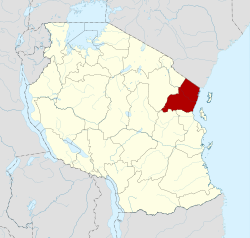
 Location in Tanzania | |
| Coordinates: 5°18′18″S 38°18′59.76″E / 5.30500°S 38.3166000°E | |
| Country | |
| Zone | Northern |
| Named for | The port of Tanga |
| Capital | Tanga |
| Districts | |
| Government | |
| • Regional Commissioner | Omary Mgumba |
| Area | |
• Total | 26,677 km2 (10,300 sq mi) |
| • Rank | 15th of 31 |
| Highest elevation (Chambolo Peak) | 2,289 m (7,510 ft) |
| Population (2022) | |
• Total | 2,615,597 |
| • Rank | 8th of 31 |
| • Density | 98/km2 (250/sq mi) |
| Demonym | Tangan |
| Ethnic groups | |
| • Settler | Swahili |
| • Native | Shambaa, Digo, Bondei, Segeju, Mbugu, Nguu, Dhaiso & Zigua |
| Time zone | UTC+3 (EAT) |
| Postcode | 21xxx |
| Area code | 027 |
| ISO 3166 code | TZ-25 |
| HDI (2021) | 0.569[1] medium · 8th of 25 |
| Website | Official website |
| Symbols of Tanzania | |
| Bird | Usambara Weaver |
| Butterfly |  |
| Fish | |
| Mammal |  |
| Tree | Ocotea usambarensis |
| Mineral | |
Tanga Region (Mkoa wa Tanga in Swahili) is one of Tanzania's 31 administrative regions. The region covers an area of 26,667 km2 (10,296 sq mi).[2] The region is comparable in size to the combined land area of the nation state of Burundi.[3] The regional capital is the municipality of Tanga city. Located in northeast Tanzania, the region is bordered by Kenya and Kilimanjaro Region to the north; Manyara Region to the west; and Morogoro and Pwani Regions to the south.[4] It has a coastline to the east with the Indian Ocean. According to the 2022 national census, the region had a population of 2,615,597.[5][6]
- ^ "Sub-national HDI - Area Database - Global Data Lab". hdi.globaldatalab.org. Archived from the original on 2018-09-23. Retrieved 2020-02-26.
- ^ "Tanga Region Size".
- ^ 25,680 km2 (9,920 sq mi) for Burundi at "Area size comparison". Nations Online. 2022. Retrieved 22 July 2022.
- ^ "Tanga Region Profile" (PDF). The Planning Commission, Dar es Salaam. 1997. Retrieved 22 July 2022.
- ^ "Tanzania: Regions and Cities - Population Statistics, Maps, Charts, Weather and Web Information". www.citypopulation.de. Retrieved 2024-02-09.
- ^ "Tanzania country profile" (PDF). Archived (PDF) from the original on 2021-08-31. Retrieved 2021-10-13.
Previous Page Next Page


