Our website is made possible by displaying online advertisements to our visitors.
Please consider supporting us by disabling your ad blocker.
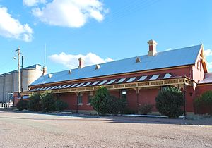
Temora railway station
Temora | |||||
|---|---|---|---|---|---|
 | |||||
| General information | |||||
| Location | Parkes Street, Temora, New South Wales Australia | ||||
| Coordinates | 34°26′46″S 147°31′42″E / 34.4460°S 147.5284°E | ||||
| Elevation | 291.9 m (958 ft) AHD | ||||
| Owned by | Transport Asset Holding Entity | ||||
| Line(s) | |||||
| Distance | 489.29 km (304.03 mi) from Central | ||||
| Other information | |||||
| Status | Closed | ||||
| History | |||||
| Opened | 1 September 1893 | ||||
| Closed | late 1970s | ||||
| Official name | Temora Railway Station group | ||||
| Type | State heritage (complex / group) | ||||
| Designated | 2 April 1999 | ||||
| Reference no. | 1265 | ||||
| Type | Railway Platform/ Station | ||||
| Category | Transport - Rail | ||||
| |||||
The Temora railway station is a heritage-listed former railway station and now youth hub and mixed-use building located on the Lake Cargelligo railway line in Temora in the Temora Shire local government area of New South Wales, Australia. The station was built from 1893 to 1915 and served the Riverina town of Temora between 1 September 1893 until its closure for passenger services in the late 1970s. The station is also known as the Temora Railway Station group. The property was added to the New South Wales State Heritage Register on 2 April 1999.[1][2]
The station had a traditional role as a transfer point for passenger services to Hillston, Lake Cargelligo, Rankin Springs, Burcher and Naradhan, most of which were withdrawn in the late 1970s. The station is not presently served by passenger services however remains an important signalling facility.
- ^ "Temora Railway Station group". New South Wales State Heritage Register. Department of Planning & Environment. H01265. Retrieved 2 June 2018.
 Text is licensed by State of New South Wales (Department of Planning and Environment) under CC BY 4.0 licence.
- ^ "Temora station". NSWrail.net. n.d. Retrieved 11 August 2009.
Previous Page Next Page


