Our website is made possible by displaying online advertisements to our visitors.
Please consider supporting us by disabling your ad blocker.
The Kymin
| The Kymin | |
|---|---|
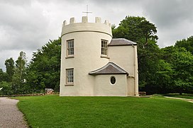
 The Round House at the Kymin, Monmouth, Wales | |
| Highest point | |
| Elevation | 256 m (840 ft) |
| Prominence | 86 m (282 ft) |
| Coordinates | 51°48′35″N 2°41′16″W / 51.80972°N 2.68778°W |
| Geography | |
| Location | Monmouth, Wales |
Listed Building – Grade II* | |
| Official name | The Kymin Roundhouse |
| Designated | 27 June 1952 |
| Reference no. | 2222 |
Listed Building – Grade II | |
| Official name | The Naval Temple with surrounding wall |
| Designated | 27 June 1952 |
| Reference no. | 2221 |
| Official name | The Kymin |
| Designated | 1 February 2022 |
| Reference no. | PGW(Gt)5(MON) |
| Listing | Grade II |
The Kymin (Welsh: Cae-y-Maen),[1] is a hill overlooking Monmouth, in Monmouthshire, Wales. It is located approximately one mile east of Monmouth, on the eastern side of the River Wye and adjacent to the border with the Forest of Dean and England. The summit of the hill, about 800 feet above sea level, is known for its neo-classical monuments, the Roundhouse and the Naval Temple, built between 1794 and 1800. It is registered on the Cadw/ICOMOS Register of Parks and Gardens of Special Historic Interest in Wales. The site is within a designated Area of Outstanding Natural Beauty (AONB) and is owned by the National Trust.
- ^ Heath 1807, p. unnumbered.
Previous Page Next Page


