Our website is made possible by displaying online advertisements to our visitors.
Please consider supporting us by disabling your ad blocker.
Thompson's Station, Tennessee
Thompson's Station, Tennessee | |
|---|---|
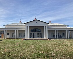
 Thompson's Station Town Hall | |
| Nickname: The Town | |
 Location of Thompson's Station in Williamson County, Tennessee | |
| Coordinates: 35°47′55″N 86°54′26″W / 35.79861°N 86.90722°W | |
| Country | United States |
| State | Tennessee |
| County | Williamson |
| Settled | 1780[1] |
| Incorporated | 1990[2] |
| Named for | Dr. Elijah Thompson, early settler[1] |
| Government | |
| • Mayor | Brian Stover |
| Area | |
• Total | 22.81 sq mi (59.06 km2) |
| • Land | 22.79 sq mi (59.03 km2) |
| • Water | 0.01 sq mi (0.03 km2) |
| Elevation | 801 ft (244 m) |
| Population | |
• Total | 7,485 |
| • Density | 328.40/sq mi (126.80/km2) |
| Time zone | UTC-6 (Central (CST)) |
| • Summer (DST) | UTC-5 (CDT) |
| ZIP code | 37179 |
| Area code | 615 |
| FIPS code | 47-73900[5] |
| GNIS feature ID | 1652469[6] |
| Website | thompsons-station.gov |
Thompson's Station is a town in Williamson County, Tennessee. The population has grown from 2,194 at the 2010 Census to 7,485 in the 2020 Census.[7] Locations in Thompson's Station listed on the U.S. National Register of Historic Places include the Jacob Critz House and the Thomas L. Critz House, Thompson's Station Bank, John Neely House, James P. Johnson House, Homestead Manor and James Giddens House.

- ^ a b Timeline of Thompson's Station, Official town website.
- ^ Tennessee Blue Book, 2005-2006, pp. 618-625.
- ^ "ArcGIS REST Services Directory". United States Census Bureau. Retrieved October 15, 2022.
- ^ Cite error: The named reference
USCensusDecennial2020CenPopScriptOnlywas invoked but never defined (see the help page). - ^ "U.S. Census website". United States Census Bureau. Retrieved January 31, 2008.
- ^ "US Board on Geographic Names". United States Geological Survey. October 25, 2007. Retrieved January 31, 2008.
- ^ "QuickFacts: Thompson's Station town, Tennessee". census.gov. Retrieved November 11, 2021.
Previous Page Next Page


