Our website is made possible by displaying online advertisements to our visitors.
Please consider supporting us by disabling your ad blocker.
Toronto subway
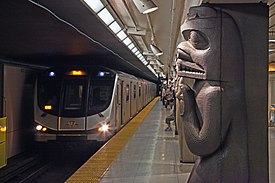
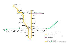
The Toronto subway is a rapid transit system serving Toronto and the neighbouring city of Vaughan in Ontario, Canada, operated by the Toronto Transit Commission (TTC). The subway system is a rail network consisting of three heavy-capacity rail lines operating predominantly underground. As of December 2024,[update] three new lines are under construction: two light rail lines (one running mostly underground, the other running mostly at-grade) and one heavy rail line (running both underground and on elevated guideways).
In 1954, the TTC opened Canada's first underground rail line, then known as the "Yonge subway", under Yonge Street between Union Station and Eglinton Avenue with 12 stations. As of 2024, the network encompasses 70 stations and 70.1 kilometres (43.6 mi) of route.[1][2] In 2023, the system had a ridership of 302,527,000, or about 1,035,300 per weekday as of the third quarter of 2024, making it the second-busiest rapid transit system in Canada in terms of daily ridership, behind the Montreal Metro. There are 60 stations under construction as part of three new lines, two light rail lines and one subway line, and two extensions to existing lines.
- ^ a b Cite error: The named reference
TTC-2013-Statswas invoked but never defined (see the help page). - ^ a b "Toronto-York Spadina Subway Extension". TTC.ca. Archived from the original on August 19, 2021. Retrieved February 8, 2017.
- ^ "Transit Ridership Report Third Quarter 2024" (PDF). American Public Transportation Association. November 20, 2024. Retrieved November 23, 2024.
- ^ "Transit Ridership Report Fourth Quarter 2023" (PDF). American Public Transportation Association. March 4, 2024. Retrieved September 5, 2024.
- ^ a b "Service Summary November 20, 2022 to January 7, 2023" (PDF). Toronto Transit Commission. November 20, 2022. Archived from the original (PDF) on December 25, 2022. Retrieved December 25, 2022.
- ^ "Eglinton Crosstown LRT". Metrolinx.com. Retrieved January 28, 2018.
- ^ "Scarborough Subway Extension". Metrolinx. January 2023. Retrieved January 28, 2023.
Previous Page Next Page


