Our website is made possible by displaying online advertisements to our visitors.
Please consider supporting us by disabling your ad blocker.
Travis County, Texas
Travis County | |
|---|---|
County | |
 | |
 Location within the U.S. state of Texas | |
 Texas's location within the U.S. | |
| Coordinates: 30°20′N 97°47′W / 30.33°N 97.78°W | |
| Country | |
| State | |
| Founded | 1840 |
| Named for | William B. Travis |
| Seat | Austin |
| Largest city | Austin |
| Area | |
• Total | 1,023 sq mi (2,650 km2) |
| • Land | 990 sq mi (2,600 km2) |
| • Water | 33 sq mi (90 km2) 3.2% |
| Population (2020) | |
• Total | 1,290,188 |
• Estimate (2023) | 1,334,961 |
| • Density | 1,303.2/sq mi (503.2/km2) |
| Time zone | UTC−6 (Central) |
| • Summer (DST) | UTC−5 (CDT) |
| Congressional districts | 10th, 17th, 21st, 35th, 37th |
| Website | traviscountytx |
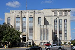
Travis County is located in Central Texas. As of the 2020 census, the population was 1,290,188. It is the fifth-most populous county in Texas. Its county seat and most populous city is Austin,[1] the state's capital. The county was established in 1840 and is named in honor of William Barret Travis, the commander of the Republic of Texas forces at the Battle of the Alamo. Travis County is part of the Austin–Round Rock–Georgetown Metropolitan Statistical Area. It is located along the Balcones Fault, the boundary between the Edwards Plateau to the west and the Blackland Prairie to the east.
- ^ "Find a County". National Association of Counties. Retrieved March 26, 2020.
Previous Page Next Page


