Our website is made possible by displaying online advertisements to our visitors.
Please consider supporting us by disabling your ad blocker.
Tremont Street
This article needs additional citations for verification. (August 2009) |
KML is from Wikidata
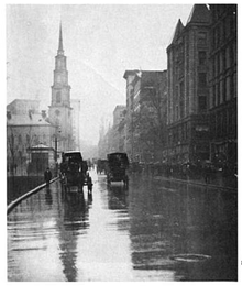
 Tremont Street and Park St. Church in 1915 | |
| Former name(s) | Treamont Street |
|---|---|
| Namesake | Trimountaine |
| Owner | City of Boston |
| Location | Boston, Massachusetts, U.S. |
| Nearest metro station | Government Center Park Street Boylston Tufts Medical Center Roxbury Crossing Brigham Circle |
| North end | Government Center, Boston |
| South end | Brigham Circle |
Tremont Street is a major thoroughfare in Boston, Massachusetts.
Tremont Street begins at Government Center in Boston's city center as a continuation of Cambridge Street, and forms the eastern edge of Boston Common. Continuing in a roughly southwesterly direction, it passes through Boston's Theater District, crosses the Massachusetts Turnpike, and becomes a broad boulevard in the South End neighborhood. It then turns to the west as a narrower four-lane street, running through Mission Hill and terminating at Brigham Circle, where it intersects Huntington Avenue. The street name zigzags across several physical roads, often requiring a sharp turn to remain on the street, as a result of changes made to the street grid during urban renewal.
Previous Page Next Page


