Our website is made possible by displaying online advertisements to our visitors.
Please consider supporting us by disabling your ad blocker.
Turtle Creek (Monongahela River tributary)
| Turtle Creek | |
|---|---|
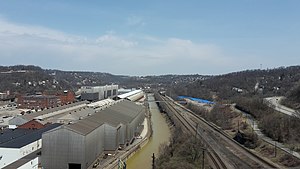
 Turtle Creek, as seen looking north from the George Westinghouse Bridge | |
 | |
| Location | |
| Country | United States |
| State | Pennsylvania |
| Counties | Westmoreland, Allegheny |
| Physical characteristics | |
| Source | |
| • coordinates | 40°25′39″N 79°34′37″W / 40.4275675°N 79.5769871°W |
| Mouth | |
• coordinates | 40°23′23″N 79°51′07″W / 40.3897913°N 79.8519929°W |
• elevation | 718.7 ft (219.1 m) |
| Length | 21.1 mi (34.0 km) |
| Basin size | 147.41 sq mi (381.8 km2) |
| Discharge | |
| • location | Wilmerding, Pennsylvania[1] |
| • average | 189 cu ft/s (5.4 m3/s) |
| • minimum | 13 cu ft/s (0.37 m3/s) |
| • maximum | 10,100 cu ft/s (290 m3/s) |
| Basin features | |
| River system | Monongahela River |
Turtle Creek | ||||||||||||||||||||||||||||||||||||||||||||||||||||||||||||||||||||||||||||||||||||||||||||||||||||||||||||||||||||||||||||||||||||||||||||||||||||||||||||||||||||||||
|---|---|---|---|---|---|---|---|---|---|---|---|---|---|---|---|---|---|---|---|---|---|---|---|---|---|---|---|---|---|---|---|---|---|---|---|---|---|---|---|---|---|---|---|---|---|---|---|---|---|---|---|---|---|---|---|---|---|---|---|---|---|---|---|---|---|---|---|---|---|---|---|---|---|---|---|---|---|---|---|---|---|---|---|---|---|---|---|---|---|---|---|---|---|---|---|---|---|---|---|---|---|---|---|---|---|---|---|---|---|---|---|---|---|---|---|---|---|---|---|---|---|---|---|---|---|---|---|---|---|---|---|---|---|---|---|---|---|---|---|---|---|---|---|---|---|---|---|---|---|---|---|---|---|---|---|---|---|---|---|---|---|---|---|---|---|---|---|---|
| ||||||||||||||||||||||||||||||||||||||||||||||||||||||||||||||||||||||||||||||||||||||||||||||||||||||||||||||||||||||||||||||||||||||||||||||||||||||||||||||||||||||||
Turtle Creek is a 21.1-mile-long (34.0 km)[2] tributary of the Monongahela River that is located in Allegheny and Westmoreland counties in the U.S. state of Pennsylvania.[3] Situated at its juncture with the Monongahela is Braddock, Pennsylvania, where the Battle of the Monongahela ("Braddock's Defeat") was fought in 1755.
During the mid-nineteenth century, the Pennsylvania Railroad laid tracks along the stream as part of its Main Line from Philadelphia to Pittsburgh.
- ^ "USGS 03084698 Turtle Creek at Wilmerding, PA". Stream Site. United States Geological Survey.
- ^ U.S. Geological Survey. National Hydrography Dataset high-resolution flowline data. The National Map, accessed August 15, 2011
- ^ "Turtle Creek". Geographic Names Information System. United States Geological Survey, United States Department of the Interior. Retrieved 2010-11-24.
Previous Page Next Page


