Our website is made possible by displaying online advertisements to our visitors.
Please consider supporting us by disabling your ad blocker.
Upper Armenia
| Բարձր Հայք | |
|---|---|
| Province of the ancient kingdom of Armenia | |
| 189 BC–11th century | |
 | |
| Capital | Ani-Kamakh |
| Area | |
• | 23,860 km2 (9,210 sq mi) |
| History | |
• Artaxias I declaring himself independent | 189 BC |
• Upper Armenia's conquest by the Byzantine Empire | 11th century |
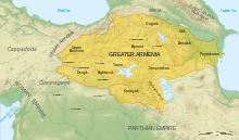
Upper Armenia (Armenian: Բարձր Հայք Bardzr Hayq) was the first province of the ancient kingdom of Armenia, located in present-day Turkey, roughly corresponding to the modern province of Erzincan, to the west of the Kura River. Within the borders of the kingdom, it was bounded by the regions of Sophene, Turuberan, Tayk, and Ayrarat. It was called Upper Armenia, as it was higher in elevation than the other provinces.
The total area of Upper Armenia was 23,860 km2 (9,000 sq mi).
It consisted of 9 cantons:
Previous Page Next Page


