Our website is made possible by displaying online advertisements to our visitors.
Please consider supporting us by disabling your ad blocker.
Uxbridge
| Uxbridge | |
|---|---|
|
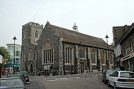
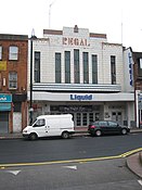
Clockwise from top: St Margaret's Church; The listed Regal Cinema building; Brunel University; Uxbridge War Memorial | |
Location within Greater London | |
| Population | 70,560 (2011 Census[note 1]) |
| OS grid reference | TQ055835 |
| • Charing Cross | 15 mi (24 km) ESE |
| London borough | |
| Ceremonial county | Greater London |
| Region | |
| Country | England |
| Sovereign state | United Kingdom |
| Post town | UXBRIDGE |
| Postcode district | UB8 |
| Dialling code | 01895 |
| Police | Metropolitan |
| Fire | London |
| Ambulance | London |
| UK Parliament | |
| London Assembly | |
Uxbridge (/ˈʌksbrɪdʒ/) is a suburban town in west London, England, and the administrative headquarters of the London Borough of Hillingdon, 15.4 miles (24.8 km) northwest of Charing Cross.[2] Uxbridge formed part of the parish of Hillingdon in the county of Middlesex. As part of the suburban growth of London in the 20th century it expanded and increased in population, becoming a municipal borough in 1955, and part of Greater London in 1965.
Attempted negotiations between King Charles I and the Parliamentary Army during the English Civil War took place at a public house where the Crown and Treaty. RAF Uxbridge houses the Battle of Britain Bunker, from where the air defence of the south-east of England was coordinated during the Battle of Britain especially from its No. 11 Group Operations Room, also used during the D-Day landings.
Today the town serves as a significant retail and commercial centre; it also houses Brunel University London as well as a campus of Buckinghamshire New University.[3] A part of the town which has large converted flour mills adjoins Buckinghamshire, the boundary being the River Colne.
The 2011 Census recorded a population of 70,560.[4]
- ^ "2011 Census Ward Population Estimates | London DataStore". Archived from the original on 22 February 2014. Retrieved 9 June 2014.
- ^ "London Plan (Consolidated with Alterations since 2004)" (PDF). Greater London Authority. 2008. p. 351. Archived from the original (PDF) on 2 June 2010. Retrieved 10 November 2011.
- ^ "About us". Buckinghamshire New University. 2013. Archived from the original on 13 October 2017. Retrieved 31 March 2013..
- ^ "Archived copy of data.london.gov.uk analysed data". Archived from the original on 22 February 2014. Retrieved 9 June 2014.
Cite error: There are <ref group=note> tags on this page, but the references will not show without a {{reflist|group=note}} template (see the help page).
Previous Page Next Page


