Our website is made possible by displaying online advertisements to our visitors.
Please consider supporting us by disabling your ad blocker.
Vaniyambadi
Vaniyambadi
Vaniampadi | |
|---|---|
Town | |
| Vaniyambadi | |
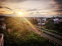
 View of Vaniyambadi town from Railroad station | |
| Nickname(s): Biryani Palace, Leather Hub | |
| Coordinates: 12°40′57″N 78°37′00″E / 12.682500°N 78.616700°E | |
| Country | |
| State | |
| Region | Tondai Nadu |
| District | Tirupathur |
| Legislative Assembly Constituency | Vaniyambadi |
| Lok Sabha Constituency | Vellore |
| First formed | August 21, 1885 |
| Named for | Goddess Saraswathi |
| Government | |
| • Type | Municipality (Selection Grade) |
| • Body | Vaniyambadi Municipality |
| Area | |
• Total | 9.54 km2 (3.68 sq mi) |
| Elevation | 371 m (1,217 ft) |
| Population (2011) | |
• Total | 95,061 |
| • Density | 9,964/km2 (25,810/sq mi) |
| Demonym | Vaniyambadian |
| Languages | |
| • Official Language | Tamil |
| Languages | |
| • Common Language | Deccani Urdu |
| Time zone | UTC+5:30 (IST) |
| PIN | 63575x |
| Telephone code | +91-4174 |
| Vehicle registration | TN 23, TN 83 |
| Literacy Rate | 85.13% |
| Sex ratio | 1023 ♂/♀ |
| Website | Vaniyambadi Municipality |
Vaniyambadi (shortly known as Vnb) (Tamil : வாணியம்பாடி) is a town in the Tirupathur district of Tamil Nadu and the headquarter for the Vaniyambadi Revenue district comprising Vaniyambadi and Ambur. It is located about 200 km from Chennai and 178 kilometer from Bengaluru. The Vaniyambadi Municipality was formed by the G.O. MS. No. 421 Local & Municipality Dept. in April 1886.[1] In 1996 this Municipality was upgraded to Grade II Municipality by G.O. MS. NO. 118 Rural Development Local Administration Dept. dated 01.05.1996. In 1998 this Municipality was upgraded to 1st Grade.
It is one of the hubs of Leather exports in Tamil Nadu.[2] It is also famous throughout India for its special Vaniyambadi Biryani. The city is the home for many prestigious century-old educational institutions viz. The Vaniyambadi Muslim Educational Society (VMES) (Estd. 1901),[3] The Hindu Higher Secondary School (Estd. 1914). The famous hill station Yelagiri is approximately 20 km away from town. Another hill station leading way through Andhra Pradesh is a short way to Kolar Gold Fields and Karnataka.
- ^ "Vaniyambadi Municipality". Government of Tamil Nadu. 2020.
- ^ Amelot, X. & Kennedy, L. (2010). Dynamique économique et recompositions territoriales, une industrie traditionnelle locale de l'Inde du sud face à la mondialisation. Annales de géographie, 671-672, 137-155. https://doi.org/10.3917/ag.671.0137
- ^ Islamiah College's VMES page. "Islamiah College". Retrieved 2 September 2022.
Previous Page Next Page


