Our website is made possible by displaying online advertisements to our visitors.
Please consider supporting us by disabling your ad blocker.
Victoria Lines
| Victoria Lines | |
|---|---|
| Northern Malta (Rabat, Mġarr, Mosta, Naxxar and Għargħur) | |
 | |
 | |
| Coordinates | 35°54′12.7″N 14°22′43.5″E / 35.903528°N 14.378750°E |
| Type | Defensive line |
| Site information | |
| Condition | Partially intact |
| Website | www.victorialinesmalta.com |
| Site history | |
| Built | 1875–1899 |
| Built by | British Empire |
| In use | 1880s–1907[a] |
| Materials | Limestone |
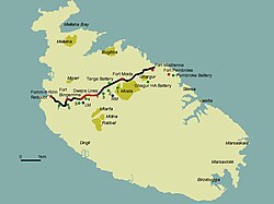
The Victoria Lines, originally known as the North West Front, are a line of fortifications that spans 12 kilometres along the width of Malta, dividing the north of the island from the more heavily populated south.[1]
Cite error: There are <ref group=lower-alpha> tags or {{efn}} templates on this page, but the references will not show without a {{reflist|group=lower-alpha}} template or {{notelist}} template (see the help page).
- ^ Spiteri, Stephen C. "The Victoria Lines". MilitaryArchitecture.com. Archived from the original on 4 August 2017. Retrieved 2 January 2015.
Previous Page Next Page


