Our website is made possible by displaying online advertisements to our visitors.
Please consider supporting us by disabling your ad blocker.
Victoria River (Northern Territory)
| Victoria River | |
|---|---|
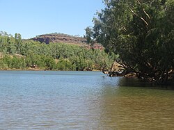
 Victoria River access, near the roadhouse Victoria River crossing | |
| Etymology | Queen Victoria[1] |
| Location | |
| Country | Australia |
| Territory | Northern Territory |
| Region | Victoria Bonaparte (IBRA) |
| Physical characteristics | |
| Source | Mount Farquharson |
| • coordinates | 17°28′16.1436″S 130°49′39.6048″E / 17.471151000°S 130.827668000°E |
| • elevation | 364 m (1,194 ft) |
| Mouth | Joseph Bonaparte Gulf |
• coordinates | 14°56′50″S 129°33′15″E / 14.94722°S 129.55417°E |
• elevation | 0 m (0 ft) |
| Length | 560 km (350 mi) |
| Basin size | 87,900 km2 (33,900 sq mi) to 99,412.5 km2 (38,383.4 sq mi)[2] |
| Discharge | |
| • location | Near mouth |
| • average | (Period: 1971–2000)345.7 m3/s (10,910 GL/a)[2] 158.4 m3/s (5,590 cu ft/s) |
| Basin features | |
| River system | Victoria River |
| Tributaries | |
| • left | Wickham, Baines, Bullo |
| • right | Camfield, Angalarri |
| National park | Judbarra / Gregory NP |
| [3][4] | |
The Victoria River is a river in the bioregion of Victoria Bonaparte in the Northern Territory of Australia. It flows for 560 kilometres (350 mi) from its source south of the Judbarra / Gregory National Park to the Joseph Bonaparte Gulf in the Timor Sea.
- ^ Cite error: The named reference
sahistorywas invoked but never defined (see the help page). - ^ a b "Victoria".
- ^ Cite error: The named reference
Bonzlewas invoked but never defined (see the help page). - ^ "Overview of the Victoria River Catchment" (PDF). Top End Waterways Project. 2005. Retrieved 29 September 2014.
Previous Page Next Page
نهر فيكتوريا (الإقليم الشمالي) Arabic نهر مولر ARZ Виктория (река) Bulgarian Victoria River (suba sa Ostralya, Northern Territory) CEB Victoria (přítok Timorského moře) Czech Виктори (юханшыв, Тимор тинĕсне кĕрет) CV Victoria River (Joseph Bonaparte Gulf) German Victoria River French Վիկտորիա (գետ) HY Viktorija (upė) LT


