Our website is made possible by displaying online advertisements to our visitors.
Please consider supporting us by disabling your ad blocker.
Virginia State Route 3
 | ||||
| Route information | ||||
| Maintained by VDOT | ||||
| Length | 150.55 mi[1] (242.29 km) | |||
| Existed | July 1, 1933[2]–present | |||
| Tourist routes | ||||
| Major junctions | ||||
| West end |
| |||
| ||||
| South end |
| |||
| Location | ||||
| Country | United States | |||
| State | Virginia | |||
| Highway system | ||||
| ||||
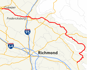
Virginia State Route 3 is a primary state highway in the U.S. state of Virginia that extends from the town of Culpeper south and eastwardly to Gloucester in Virginia's Middle Peninsula region. For many years, a portion was named "Historyland Highway".
- ^ 2010 Virginia Department of Transportation Traffic Data Culpeper County - Orange County - Spotsylvania County - City of Fredericksburg - Stafford County - King George County - Westmoreland County - Richmond County - Lancaster County - Middlesex County - Mathews County - Gloucester County
- ^ "New Numbers of Va. Highways Effective July 1". The Richmond Times-Dispatch. May 10, 1933. p. 5. Retrieved January 21, 2020 – via Newspapers.com.

Previous Page Next Page


