Our website is made possible by displaying online advertisements to our visitors.
Please consider supporting us by disabling your ad blocker.
Visayas
Native name:
| |
|---|---|
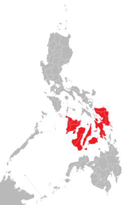
 Location of the Visayas within the Philippines | |
 | |
| Geography | |
| Location | Southeast Asia |
| Archipelago | Philippines |
| Major islands | |
| Area | 71,503 km2 (27,607 sq mi) |
| Highest elevation | 2,465 m (8087 ft) |
| Highest point | Mount Kanlaon |
| Administration | |
| Regions | |
| Largest settlement | Cebu City (pop. 964,169) |
| Demographics | |
| Demonym |
|
| Population | 21,155,014 (2021)[1] |
| Pop. density | 292/km2 (756/sq mi) |
| Ethnic groups | |
The Visayas (/vɪˈsaɪəz/ viss-EYE-əz), or the Visayan Islands[2] (Visayan: Kabisay-an, locally [kabiˈsajʔan]; Filipino: Kabisayaan [kɐbɪsɐˈjaʔan]), are one of the three principal geographical divisions of the Philippines, along with Luzon and Mindanao. Located in the central part of the archipelago, it consists of several islands, primarily surrounding the Visayan Sea, although the Visayas are also considered the northeast extremity of the entire Sulu Sea.[3] Its inhabitants are predominantly the Visayan peoples.
The major islands of the Visayas are Panay, Negros, Cebu, Bohol, Leyte and Samar.[6] The region may also include the provinces of Palawan, Romblon, and Masbate, whose populations identify as Visayan and whose languages are more closely related to other Visayan languages than to the major languages of Luzon.
There are four administrative regions in the Visayas: Western Visayas (pop. 4.73 million), Negros Island Region (pop. 4.76 million), Central Visayas (6.54 million) and Eastern Visayas (4.5 million).[7]
- ^ Census of Population (2015). Highlights of the Philippine Population 2015 Census of Population. Philippine Statistics Authority. Retrieved June 20, 2016.
- ^ "Visayan Islands" Merriam-Webster Dictionary. http://www.merriam-webster.com/concise/visayan%20islands
- ^ C. Michael Hogan. 2011. Sulu Sea. Encyclopedia of Earth. Eds. P. Saundry & C. J. Cleveland. Washington, D.C.
- ^ "Executive Order No. 429". President of the Philippines. Archived from the original on July 7, 2007. Retrieved May 18, 2009.
- ^ "Administrative Order No. 129". President of the Philippines. Archived from the original on July 13, 2009. Retrieved May 18, 2009.
- ^ On May 23, 2005, Palawan and Puerto Princesa City were moved to Western Visayas by Executive Order No. 429.[4] However, on August 19, 2005, President Arroyo issued Administrative Order No. 129 to hold the earlier E.O. 429 in abeyance pending a review.[5] As of 2010[update], Palawan and the highly urbanized city of Puerto Princesa still remain a part of the Mimaropa region.
- ^ "PSA Makati ActiveStats – PSGC Interactive – List of Regions". Philippine Statistics Authority. June 30, 2015. Archived from the original on October 13, 2008. Retrieved September 18, 2015.
Previous Page Next Page


