Our website is made possible by displaying online advertisements to our visitors.
Please consider supporting us by disabling your ad blocker.
Vledder
Vledder | |
|---|---|
 Johannes de Doperkerk | |
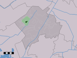
 The village centre (dark green) and the statistical district (light green) of Vledder in the municipality of Westerveld. | |
| Coordinates: 52°51′20″N 6°12′37″E / 52.85556°N 6.21028°E | |
| Country | Netherlands |
| Province | Drenthe |
| Municipality | Westerveld |
| Area | |
• Total | 12.68 km2 (4.90 sq mi) |
| Elevation | 6 m (20 ft) |
| Population (2021)[1] | |
• Total | 1,960 |
| • Density | 150/km2 (400/sq mi) |
| Time zone | UTC+1 (CET) |
| • Summer (DST) | UTC+2 (CEST) |
| Postal code | 8381[1] |
| Dialing code | 0521 |
Vledder (Dutch pronunciation: [ˈvlɛdər]) is a village in the Dutch province of Drenthe. It is a part of the municipality of Westerveld, and lies about 24 km northwest of Hoogeveen. It is located along the small river Vledder Aa.
- ^ a b c "Kerncijfers wijken en buurten 2021". Central Bureau of Statistics. Retrieved 12 April 2022.
- ^ "Postcodetool for 8381AA". Actueel Hoogtebestand Nederland (in Dutch). Het Waterschapshuis. 24 July 2019. Retrieved 12 April 2022.
Previous Page Next Page


