Our website is made possible by displaying online advertisements to our visitors.
Please consider supporting us by disabling your ad blocker.
Volta River
This article is missing information about the name of the river in local languages. (August 2022) |
| Volta River Fleuve Volta | |
|---|---|
 The Adomi Bridge crosses the Volta river south of the Akosombo Dam. | |
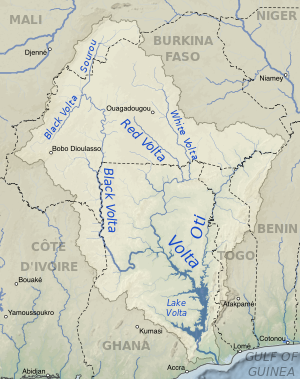
 Map of the Volta River drainage basin and its main three tributaries, the White Volta, Red Volta, and Black Volta rivers | |
| Location | |
| Countries | |
| Physical characteristics | |
| Mouth | Gulf of Guinea |
• location | Atlantic Ocean |
• coordinates | 5°46′N 0°41′E / 5.767°N 0.683°E[1] |
| Length | 1,500 km (930 mi) |
| Basin size | 407,093 km2 (157,179 sq mi)[2] |
| Discharge | |
| • location | Mouth[3] |
| • average | 1,210 m3/s (43,000 cu ft/s)[3] |
 | |
The Volta River (Akan: Asuo Firaw, Ewe: Amuga, French: Fleuve Volta) is the main river system in the West African country of Ghana. It flows south into Ghana from the Bobo-Dioulasso highlands of Burkina Faso. The main parts of the river are the Black Volta, the White Volta, and the Red Volta. In the northwest, the Black Volta forms the international borders between the Ivory Coast, Ghana, and Burkina Faso. The Volta flows southward along the Akwapim-Togoland highlands, and empties into the Atlantic Ocean at the Gulf of Guinea at Ada Foah. One of its smaller tributaries, the Oti River, enters Ghana from Togo in the east. The Volta River has been dammed at Akosombo for generating hydroelectricity. The reservoir named Lake Volta stretches from Akosombo Dam in the south to the northern part of the country, and is the largest man-made reservoir by area in the world.[4]
The country of Burkina Faso was formerly called Upper Volta, after the river.

- ^ Volta at GEOnet Names Server
- ^ Volta Archived 2005-10-26 at the Wayback Machine, Watersheds of the World. Water Resources eAtlas. Retrieved on October 6, 2007.
- ^ a b Volta River, Encyclopædia Britannica. 2007. Encyclopædia Britannica Online Library Edition. Retrieved on October 6, 2007.
- ^ "Lake Volta, Ghana". Visible Earth. NASA. 7 April 2002. Retrieved 7 March 2018.
Previous Page Next Page


