Our website is made possible by displaying online advertisements to our visitors.
Please consider supporting us by disabling your ad blocker.
Vyborgsky District, Leningrad Oblast
Vyborgsky District
Выборгский район | |
|---|---|
 Lake Zerkalnoye in Vyborgsky District | |
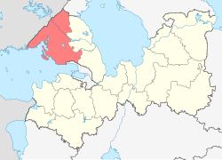
 Location of Vyborgsky District in Leningrad Oblast | |
| Coordinates: 60°42′33″N 28°44′39″E / 60.70917°N 28.74417°E | |
| Country | Russia |
| Federal subject | Leningrad Oblast[1] |
| Established | March 1940[2] |
| Administrative center | Vyborg[1] |
| Area | |
• Total | 7,475 km2 (2,886 sq mi) |
| Population | |
• Total | 120,446 |
| • Density | 16/km2 (42/sq mi) |
| • Urban | 43.3% |
| • Rural | 56.7% |
| Administrative structure | |
| • Administrative divisions | 5 Settlement municipal formations (towns), 2 Settlement municipal formations (urban-type settlements), 5 Settlement municipal formations (rural settlements) |
| • Inhabited localities[1] | 5 cities/towns, 3 urban-type settlements[5], 173 rural localities |
| Municipal structure | |
| • Municipally incorporated as | Vyborgsky Municipal District[6] |
| • Municipal divisions[6] | 7 urban settlements, 5 rural settlements |
| Time zone | UTC+3 (MSK |
| OKTMO ID | 41615000 |
| Website | http://www.vbglenobl.ru/ |
Vyborgsky District (Russian: Вы́боргский райо́н, romanized: Výborgskiy raión, IPA: [ˈvɨbərkskʲɪj rɐˈjɵn]) is an administrative[1] and municipal[6] district (raion), one of the seventeen in Leningrad Oblast, Russia. It is located in the northwest of the oblast on the Karelian Isthmus and borders with Priozersky District in the northeast, Vsevolozhsky District in the east, Kurortny District of the federal city of St. Petersburg in the south, Kymenlaakso and South Karelia regions of Finland in the northwest, and Lakhdenpokhsky District of the Republic of Karelia in the north. From the southwest, the district is limited by the Gulf of Finland. The area of the district is 7,475.472 square kilometers (2,886.296 sq mi).[3] Its administrative center is the town of Vyborg.[1] Population (excluding the administrative center): 120,446 (2010 Census);[4] 113,748 (2002 Census);[8] 108,571 (1989 Soviet census).[9]
- ^ a b c d e Oblast Law #32-oz
- ^ Cite error: The named reference
histwas invoked but never defined (see the help page). - ^ a b О районе (in Russian). Муниципальное образование "Выборгский район" Ленинградской Области. Retrieved June 19, 2013.
- ^ a b Russian Federal State Statistics Service (2011). Всероссийская перепись населения 2010 года. Том 1 [2010 All-Russian Population Census, vol. 1]. Всероссийская перепись населения 2010 года [2010 All-Russia Population Census] (in Russian). Federal State Statistics Service.
- ^ The count of urban-type settlements may include the work settlements, the resort settlements, the suburban (dacha) settlements, as well as urban-type settlements proper.
- ^ a b c Law #17-oz
- ^ "Об исчислении времени". Официальный интернет-портал правовой информации (in Russian). June 3, 2011. Retrieved January 19, 2019.
- ^ Federal State Statistics Service (May 21, 2004). Численность населения России, субъектов Российской Федерации в составе федеральных округов, районов, городских поселений, сельских населённых пунктов – районных центров и сельских населённых пунктов с населением 3 тысячи и более человек [Population of Russia, Its Federal Districts, Federal Subjects, Districts, Urban Localities, Rural Localities—Administrative Centers, and Rural Localities with Population of Over 3,000] (XLS). Всероссийская перепись населения 2002 года [All-Russia Population Census of 2002] (in Russian).
- ^ Всесоюзная перепись населения 1989 г. Численность наличного населения союзных и автономных республик, автономных областей и округов, краёв, областей, районов, городских поселений и сёл-райцентров [All Union Population Census of 1989: Present Population of Union and Autonomous Republics, Autonomous Oblasts and Okrugs, Krais, Oblasts, Districts, Urban Settlements, and Villages Serving as District Administrative Centers]. Всесоюзная перепись населения 1989 года [All-Union Population Census of 1989] (in Russian). Институт демографии Национального исследовательского университета: Высшая школа экономики [Institute of Demography at the National Research University: Higher School of Economics]. 1989 – via Demoscope Weekly.
Previous Page Next Page
Выбаргскі раён (Ленінградская вобласць) BE Выбарскі раён (Ленінградзкая вобласьць) BE-X-OLD Выборган кӀошт (Ленинградан область) CE Vyborgskiy Rayon (rayon) CEB Wyborgski rajon (Leningrad) German Viiburi rajoon ET Viipurin piiri (Leningradin alue) Finnish Raïon de Vyborg French נפת ויבורג (מחוז לנינגרד) HE Վիբորգի շրջան HY


