Our website is made possible by displaying online advertisements to our visitors.
Please consider supporting us by disabling your ad blocker.
Wacker Drive
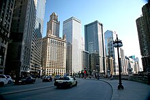
 Upper Wacker Drive, looking west from Michigan Avenue | |
 Wacker Drive highlighted in red | |
| Former name(s) | Market Street Water Street River Street |
|---|---|
| Length | 2.2 mi (3.5 km)[1] |
| South end | Upper Wacker: Franklin Street/Harrison Street intersection (360 west at 424 south) Lower Wacker: Ida B. Wells Drive near Wells Street (220 west at 400 south) |
| East end | |
| Construction | |
| Inauguration | 1926 |
Wacker Drive is a major multilevel street in Chicago, Illinois, running along the south side of the main branch and the east side of the south branch of the Chicago River in the Loop.[2] The vast majority of the street is double-decked; the upper level is intended for regular street-level traffic, and the lower level for service vehicles, deliveries, waste collection, utility access, and through traffic. It is sometimes cited as a precursor to the freeway, though when it was built, the idea was that pleasure vehicles would use the upper level. Since it follows the curving path of the Chicago River, Lower Wacker Drive is the only street in the city that adopts both North–South and East–West designations.[a] In certain areas, there is a third level of Wacker Drive, often known as Lower Lower Wacker Drive or Sub-Lower Wacker Drive. This additional layer is primarily used for towing and impounding vehicles, utility infrastructure, and rail access in some areas. The street is named after early 20th-century Chicago businessman and city planner Charles H. Wacker.
- ^ Google Maps estimate.
- ^ Hayner, Don and Tom McNamee, Streetwise Chicago, "Wacker Drive", p. 129., Loyola University Press, 1988, ISBN 0-8294-0597-6
Cite error: There are <ref group=lower-alpha> tags or {{efn}} templates on this page, but the references will not show without a {{reflist|group=lower-alpha}} template or {{notelist}} template (see the help page).
Previous Page Next Page


