Our website is made possible by displaying online advertisements to our visitors.
Please consider supporting us by disabling your ad blocker.
Wade's Causeway
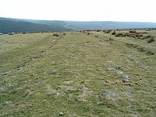
 Wade's Causeway, c. 2005 | |
| Alternative name |
|
|---|---|
| Location | Egton Parish, North Yorkshire, England |
| Coordinates | 54°22′14″N 0°45′33″W / 54.370575°N 0.759134°W |
| Type | linear monument, possibly road or dike |
| Length | between 1.2 and 25 miles (1.9 and 40.2 km) |
| History | |
| Builder | Disputed |
| Material | sandstone[1][2][3] |
| Founded | Uncertain |
| Abandoned | Uncertain |
| Periods | Variously contended to be Neolithic, Bronze Age, Iron Age, Roman or Medieval |
| Site notes | |
| Excavation dates | 1912–1964 (not continuous) |
| Archaeologists | James Patterson,[4] Oxley Grabham,[5][6] Tempest Anderson,[6] James Rutter, Raymond Hayes, J. Ingram, A. Precious, P. Cook |
| Condition | ruined, overgrown, heavily robbed |
| Ownership | Duchy of Lancaster[1] |
| Management | North York Moors National Park Authority, in cooperation with English Heritage[8] |
| Public access | Yes[7] |
| Reference no. | 1004876[9] |
| UID | NY 309 |
| National Grid Reference | SE 80680 97870 |
Wade's Causeway is a Roman road, or possibly a Neolithic structure, located in the North York Moors national park in North Yorkshire, England. Its origins, age, purpose and extent are subject to ongoing research and debate and have not been reliably established.
it was excavated in mid-20th century and dated to the Roman period, but 21st century re-interpretations have suggested a possible Neolithic origin. The name may be used to refer specifically to scheduled ancient monument number 1004876, a length of stone course just over 1 mile (1.6 km) long on Wheeldale Moor. It may be also be applied more broadly to include an additional postulated extension of this structure, incorporating ancient monuments numbers 1004108 and 1004104 which extend to the north and south of Wheeldale for up to 25 miles (40 km). The visible course on Wheeldale Moor consists of an embankment of soil, peat, gravel and loose pebbles 0.7 metres (2.3 ft) in height and 4 to 7 metres (13 to 23 ft) in width. The gently cambered embankment is capped with un-mortared and loosely abutted flagstones. Its original form is uncertain since it has been subjected to weathering and human damage.
The structure has been the subject of folklore in the surrounding area for several hundred years and possibly for more than a millennium. Its construction was commonly attributed to a giant known as Wade, a figure from Germanic mythology. In the 1720s, the causeway was mentioned in a published text and as a result became more widely known outside the local area for the first time. Within a few years, it became of interest to antiquarians, who visited the site and exchanged commentary on its probable historicity. They interpreted the structure as a causeway across marshy ground, attributing its construction to the Roman military, an explanation that remained largely unchallenged throughout the remainder of the eighteenth and nineteenth centuries.
The stretch of the causeway on Wheeldale Moor was cleared of vegetation and excavated in the early twentieth century by a local gamekeeper interested in archaeology. The historian Ivan Margary agreed with its identification as a Roman road and assigned it the catalogue number 81b in the first edition of his Roman Roads In Britain (1957). The causeway was further excavated and studied by the archaeologist Raymond Hayes in the 1950s and 1960s, partly funded by the Council for British Archaeology. His investigation concluded that the structure was a Roman road and the resulting report was published in 1964 by the Scarborough Archaeological and Historical Society.
In the late twentieth and early twenty-first centuries, its identification as a Roman road has been questioned by academics, and alternative interpretations suggested for its purpose and date of construction, including its possible origin as a neolithic structure up to 6,000 years old. The monument's co-manager, English Heritage, in 2012, proposed several avenues of research that might be used to settle some of the questions that have arisen regarding its origins and usage.
- ^ Young 1817, p. 706.
- ^ Hayes & Rutter 1964, p. 85.
- ^ Lee 1997, p. 12.
- ^ Barker 1977, p. 63.
- ^ PCNFC 1910.
- ^ a b WNC Annual Reports 1956, p. 23.
- ^ Great Britain. Department of the Environment 1976, p. 12.
- ^ English Heritage (4) 2013.
- ^ Historic England (1) 2013.
Previous Page Next Page


