Our website is made possible by displaying online advertisements to our visitors.
Please consider supporting us by disabling your ad blocker.
Wakhan Corridor
| Wakhan Corridor | |||||||||||||
|---|---|---|---|---|---|---|---|---|---|---|---|---|---|
 Wakhan Corridor | |||||||||||||
 | |||||||||||||
| Chinese name | |||||||||||||
| Simplified Chinese | 瓦罕走廊 | ||||||||||||
| Traditional Chinese | 瓦罕走廊 | ||||||||||||
| Literal meaning | Wakhan Corridor | ||||||||||||
| |||||||||||||
| Alternative Chinese name | |||||||||||||
| Simplified Chinese | 阿富汗走廊 | ||||||||||||
| Traditional Chinese | 阿富汗走廊 | ||||||||||||
| Literal meaning | Afghan Corridor | ||||||||||||
| |||||||||||||
| Second alternative Chinese name | |||||||||||||
| Simplified Chinese | 瓦罕帕米尔 | ||||||||||||
| Traditional Chinese | 瓦罕帕米爾 | ||||||||||||
| Literal meaning | Wakhan Pamir | ||||||||||||
| |||||||||||||
| Pashto name | |||||||||||||
| Pashto | دهلېز واخان | ||||||||||||
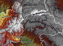
The Wakhan Corridor (Dari: دالان واخان, romanized: Dâlân-e wâxân; Pashto: واخان دهلېز, romanized: Vâxân dahléz) is a narrow strip of territory in the Badakhshan province of Afghanistan. This corridor stretches eastward, connecting Afghanistan to Xinjiang, China. It also separates the Gorno-Badakhshan Autonomous Region of Tajikistan in the north from the Khyber Pakhtunkhwa and Gilgit-Baltistan regions of Pakistan in the south, the latter of which is also part of the disputed region of Kashmir.[1][2][3][4][5][a] This high mountain valley, which rises to a maximum altitude of 4,923 m (16,152 ft), serves as the source of both the Panj and Pamir rivers, which converge to form the larger Amu Darya River. For countless centuries, a vital trade route has traversed this valley, facilitating the movement of travelers to and from East, South, and Central Asia.[6]
The corridor was formed after an 1893 agreement between Mortimer Durand of the British Raj and Emir Abdur Rahman Khan of Afghanistan, creating the Durand Line.[7] This narrow strip acted as a buffer zone between the Russian Empire and the British Empire (the regions of Russian Turkestan, now in Tajikistan and the northern part of British Raj, now in Pakistan). Its eastern end bordered China's Xinjiang region, then claimed by the Qing dynasty.
The corridor is in the Wakhan District of Afghanistan's Badakhshan province. As of 2020, it had 17,167 residents.[8] The northern part of the Wakhan, populated by the Wakhi and Pamiri people, is also referred to as the Pamir. The closest major airport for the residents to use is Fayzabad Airport in the city of Fayzabad to the west, which can be reached by a road network.
- ^ Bruce Elleman; Stephen Kotkin; Clive Schofield (18 May 2015). Beijing's Power and China's Borders: Twenty Neighbors in Asia. M.E. Sharpe. pp. 13–. ISBN 978-0-7656-2766-7.
The Sino-Afghan border was delimited in a secret treaty signed during November 1963. The corridor shares a border with Pakistan to its south and Tajikistan to its north.
- ^ Pervaiz I Cheema; Manuel Riemer (22 August 1990). Pakistan's Defence Policy 1947-58. Palgrave Macmillan UK. pp. 46–. ISBN 978-1-349-20942-2.
In addition, the Soviet Union is separated from Pakistani territory by a small strip commonly known as the Wakhan corridor. Theoretically the Soviet Union does not have a common border with Pakistan but in view of their close linkage with Afghanistan and the shortness of Wakhan's breadth make it an immediate neighbour for all practical purposes.
- ^ Yasmeen Niaz Mohiuddin (2007). Pakistan: A Global Studies Handbook. ABC-CLIO. pp. 18–. ISBN 978-1-85109-801-9.
The Chitral and Kalash valleys of the Hindu Kush Mountains are located north of the Swat Valley in the Chitral district of the North-West Frontier Province and are bordered by Afghanistan on the north, south, and west. The Wakhan Corridor separates Pakistan from Tajikistan. The corridor, wedged between the Pamir Mountains to the north and the Karakoram range to the south, is about 350 km (220 mi) long and 13–65 kilometres (8–40 mi) wide.
- ^ International Boundary Study of the Afghanistan–USSR Boundary (1983) by the US Bureau of Intelligence and Research Pg. 7. Archived on 2011-06-07
- ^ Ashraf, Fahmida (1986). "The Strategic Wakhan". Strategic Studies. 9 (2): 48–67. ISSN 1029-0990. JSTOR 45182417. Archived from the original on 5 April 2023. Retrieved 4 April 2023.
- ^ "Wakhan Corridor travel guide". Caravanistan. Retrieved 29 October 2018.
- ^ Nystrop, Richard F. And Donald M. Seekins, eds. Afghanistan a Country Study. Washington: Library of Congress, 1986, p. 38.
- ^ https://web.archive.org/web/20210624204559/https://www.nsia.gov.af:8080/wp-content/uploads/2021/06/Estimated-Population-of-Afghanistan1-1400.pdf (p. 87)
Cite error: There are <ref group=lower-alpha> tags or {{efn}} templates on this page, but the references will not show without a {{reflist|group=lower-alpha}} template or {{notelist}} template (see the help page).
Previous Page Next Page


