Our website is made possible by displaying online advertisements to our visitors.
Please consider supporting us by disabling your ad blocker.
Warburton Highway
This article needs additional citations for verification. (January 2014) |
Warburton Highway | |
|---|---|
 | |
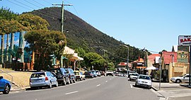
| Main Street in Warburton | |
| Coordinates | |
| General information | |
| Type | Highway |
| Length | 34 km (21 mi)[3] |
| Gazetted | October 1913 (as Main Road)[1] 1959/60 (as State Highway)[2] |
| Route number(s) | |
| Former route number | |
| Major junctions | |
| West end | Lilydale, Melbourne |
| |
| East end | Warburton, Victoria |
| Location(s) | |
| Major settlements | Wandin North, Seville, Woori Yallock, Launching Place, Wesburn, Millgrove |
| Highway system | |
| ---- | |
Warburton Highway is a 34 kilometre west–east semi-rural highway on the eastern fringes of Melbourne, Victoria, linking Lilydale to Warburton[4] in the Yarra Valley wine region, as well as Melbourne's closest mountain peak to receive regular snowfall, Mount Donna Buang.
- ^ "Victorian Government Gazette". State Library of Victoria. 5 November 1913. p. 4812. Retrieved 4 June 2024.
- ^ "Country Roads Board Victoria. Forty-Seventh Annual Report: for the year ended 30 June 1960". Country Roads Board of Victoria. Melbourne: Victorian Government Library Service. 21 November 1960. pp. 7–8.
- ^ "Warburton Highway" (Map). Google Maps. Retrieved 18 October 2021.
- ^ Cite error: The named reference
vicregwas invoked but never defined (see the help page).
Previous Page Next Page


