Our website is made possible by displaying online advertisements to our visitors.
Please consider supporting us by disabling your ad blocker.
Waroona, Western Australia
| Waroona Western Australia | |||||||||||||||
|---|---|---|---|---|---|---|---|---|---|---|---|---|---|---|---|
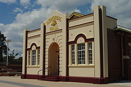
 Waroona Memorial Hall | |||||||||||||||
 | |||||||||||||||
| Coordinates | 32°52′00″S 115°55′00″E / 32.86667°S 115.91667°E | ||||||||||||||
| Population | 2,368 (UCL 2021)[1] | ||||||||||||||
| Established | 1895 | ||||||||||||||
| Postcode(s) | 6215 | ||||||||||||||
| Area | 241.2 km2 (93.1 sq mi) | ||||||||||||||
| Location | |||||||||||||||
| LGA(s) | Shire of Waroona | ||||||||||||||
| State electorate(s) | Murray-Wellington | ||||||||||||||
| Federal division(s) | Canning | ||||||||||||||
| |||||||||||||||
Waroona is a town located in the Peel region of Western Australia along the South Western Highway, between Pinjarra and Harvey. The town is the seat of the Shire of Waroona. At the 2016 census, Waroona had a population of 2,934.[2]
- ^ Australian Bureau of Statistics (28 June 2022). "Waroona (urban centre and locality)". Australian Census 2021.
- ^ "2016 Census QuickStats: Waroona". quickstats.censusdata.abs.gov.au. Retrieved 2 June 2019.
Previous Page Next Page


