Our website is made possible by displaying online advertisements to our visitors.
Please consider supporting us by disabling your ad blocker.
Washington State Route 501
| Erwin O. Rieger Memorial Highway | ||||
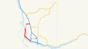
 The existing highway is highlighted in red. The proposed completion is shown in dashed purple. | ||||
| Route information | ||||
| Auxiliary route of I-5 | ||||
| Maintained by WSDOT | ||||
| Length | 13.97 mi[1] (22.48 km) | |||
| Existed | 1964[2]–present | |||
| Southern section | ||||
| Length | 11.00 mi[1] (17.70 km) | |||
| South end | ||||
| North end | Ridgefield NWR near Vancouver | |||
| Northern section | ||||
| Length | 2.97 mi[1] (4.78 km) | |||
| West end | Main Street in Ridgefield | |||
| East end | ||||
| Location | ||||
| Country | United States | |||
| State | Washington | |||
| Counties | Clark | |||
| Highway system | ||||
| ||||
State Route 501 (SR 501, designated as the Erwin O. Rieger Memorial Highway) is a 13.97-mile-long (22.48 km) state highway in the southern part of the U.S. state of Washington. It is split into two sections in Clark County, a north–south alignment connecting Interstate 5 (I-5) in Vancouver to the Port of Vancouver and the Ridgefield National Wildlife Refuge, and a west–east alignment connecting Ridgefield to I-5. Prior to the 1964 highway renumbering, SR 501 was designated as Secondary State Highway 1T (SSH 1T), established in 1937 and re-aligned to serve the Port of Vancouver in 1963.
- ^ a b c Strategic Planning Division (March 5, 2012). State Highway Log Planning Report 2011, SR 2 to SR 971 (PDF) (Report). Washington State Department of Transportation. pp. 1482–1487. Retrieved February 10, 2013.
- ^ "47.17.640: State route No. 501 — Erwin O. Rieger Memorial Highway". Revised Code of Washington (Revised ed.). Washington State Legislature. 1991 [1970]. Retrieved February 10, 2013.
Previous Page Next Page


