Our website is made possible by displaying online advertisements to our visitors.
Please consider supporting us by disabling your ad blocker.
Wattle Range Council
| Wattle Range Council South Australia | |||||||||||||||
|---|---|---|---|---|---|---|---|---|---|---|---|---|---|---|---|
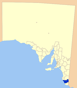
 Position of the Wattle Range Council | |||||||||||||||
| Coordinates | 37°27′55″S 140°30′00″E / 37.4653°S 140.4999°E | ||||||||||||||
| Population | 11,888 (LGA 2021)[1] | ||||||||||||||
| • Density | 3,03/km2 (780/sq mi) | ||||||||||||||
| Established | 1997 | ||||||||||||||
| Area | 3,923.5 km2 (1,514.9 sq mi) | ||||||||||||||
| Mayor | Des Noll | ||||||||||||||
| Council seat | Millicent | ||||||||||||||
| Region | Limestone Coast[2] | ||||||||||||||
| State electorate(s) | MacKillop, Mount Gambier | ||||||||||||||
| Federal division(s) | Barker | ||||||||||||||
 | |||||||||||||||
| Website | Wattle Range Council | ||||||||||||||
| |||||||||||||||
Wattle Range Council is a local government area in the Limestone Coast region of South Australia. It stretches from the coast at Beachport east to the Victorian border. It had a population of over 11,000 as at the 2016 Census.
The council is divided into four wards; Kintore, Riddoch, Sorby Adams and Corcoran wards, with two or more councillors representing each ward. The council seat is located at Millicent.[3]
- ^ Australian Bureau of Statistics (28 June 2022). "Wattle Range (Local Government Area)". Australian Census 2021 QuickStats. Retrieved 28 June 2022.
- ^ "Limestone Coast SA Government region" (PDF). The Government of South Australia. Retrieved 10 October 2014.
- ^ "Wattle Range Council". Retrieved 12 April 2016.
Previous Page Next Page


