Our website is made possible by displaying online advertisements to our visitors.
Please consider supporting us by disabling your ad blocker.
Wellington Airport
Wellington International Airport Taunga Rererangi o Te Whanganui-a-Tara (Māori) | |||||||||||
|---|---|---|---|---|---|---|---|---|---|---|---|
 | |||||||||||
 | |||||||||||
| Summary | |||||||||||
| Airport type | Public | ||||||||||
| Owner |
| ||||||||||
| Operator | Wellington International Airport Ltd | ||||||||||
| Serves | Wellington | ||||||||||
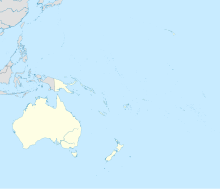
| Location | Rongotai, Wellington, New Zealand | ||||||||||
| Opened | 25 October 1959 | ||||||||||
| Hub for | |||||||||||
| Time zone | NZST (UTC+12:00) | ||||||||||
| • Summer (DST) | NZDT (UTC+13:00) | ||||||||||
| Elevation AMSL | 13 m / 42 ft | ||||||||||
| Coordinates | 41°19′38″S 174°48′19″E / 41.32722°S 174.80528°E | ||||||||||
| Website | www | ||||||||||
| Map | |||||||||||
 | |||||||||||
| Runways | |||||||||||
| |||||||||||
| Statistics (year ending 30 June 2019) | |||||||||||
| |||||||||||
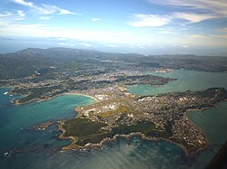
Wellington International Airport[4] (IATA: WLG, ICAO: NZWN) — formerly known as Rongotai Aerodrome or Rongotai Airport, or simply Wellington Airport — is an international airport located in the suburb of Rongotai in Wellington, the capital of New Zealand. It lies 5.5 km (3.0 nmi; 3.4 mi) south-east from the city centre. It is a hub for Air New Zealand and Sounds Air. Wellington International Airport Limited, a joint venture between Infratil and the Wellington City Council, operates the airport. Wellington is the third busiest airport in New Zealand after Auckland and Christchurch, handling a total of 3,455,858 passengers in the year ending June 2022, and the third busiest in terms of aircraft movements.[5] The airport, in addition to linking many New Zealand destinations with national and regional carriers, also has links to major cities in eastern Australia. It is the home of some smaller general aviation businesses, including the Wellington Aero Club, which operates from the general aviation area on the western side of the runway.
The airport comprises a small 110-hectare (270-acre)[6] site on the Rongotai isthmus, a stretch of low-lying land between Wellington proper and the hilly Miramar Peninsula. It operates a single 2,081-metre (6,827 ft) runway with ILS in both directions. The airport handles turboprop, narrow-body and wide-body jet aircraft movements. The airport is bordered by residential and commercial areas to the east and west, and by Evans Bay in Wellington Harbour to the north and Cook Strait to the south.
Wellington has a reputation for sometimes rough and turbulent landings, even in larger aircraft, due to the channelling effect of Cook Strait creating strong and gusty winds, especially in pre-frontal north-westerly conditions.[7][8]
- ^ "Wellington (NZWN) Aerodrome Geographical and Administration Data" (PDF). Civil Aviation Authority. 12 August 2021. Retrieved 16 December 2024.
- ^ "June Market Report" (PDF). Wellington International Airport. Retrieved 9 November 2009.
- ^ "Business statistics – Wellington International Airport". Archived from the original on 6 May 2015. Retrieved 2 February 2014.
- ^ "WLG 2040" (PDF).
- ^ "Domestic and International Aircraft Movements by Calendar Year" (PDF). Airways New Zealand. Retrieved 16 April 2023.
- ^ "Wellington Airport: Frequently Asked Questions". Infratil. Archived from the original on 28 September 2007. Retrieved 5 December 2007.
- ^ "Landing at Wellington – Aviation". Te Ara Encyclopedia of New Zealand. Archived from the original on 17 September 2011. Retrieved 8 December 2011.
- ^ "Wellington Airport, New Zealand – World's scariest airport landing strips". Virgin Media. Archived from the original on 15 August 2011. Retrieved 8 December 2011.
Previous Page Next Page
مطار ويلينغتون الدولي Arabic مطار ويلينجتون الدولى ARZ Aeropuertu Internacional de Wellington AST Wellington International Airport CEB Flughafen Wellington German Aeropuerto Internacional de Wellington Spanish فرودگاه بینالمللی ولینگتون FA Wellingtonin kansainvälinen lentoasema Finnish Aéroport international de Wellington French Aeroporto de Wellington GL


