Our website is made possible by displaying online advertisements to our visitors.
Please consider supporting us by disabling your ad blocker.
West Branch Susquehanna Valley


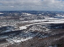
The West Branch Susquehanna Valley of central Pennsylvania, United States, in the Ridge-and-valley Appalachians, is the low-lying area draining into the West Branch Susquehanna River southeast of the Allegheny Front, northeast of the Bald Eagle Valley, southwest of the Wyoming Valley and north of the water gap formed between Shamokin Mountain and Montour Ridge.
The river enters the valley after emerging from a deep gorge in the Allegheny Plateau above Lock Haven, then turns east entering a broad alluvial flood plain, where it receives the Bald Eagle Creek after passing the town. The flood plain lies at the foot of the Bald Eagle Mountain ridge, with large fertile farm fields in and around the river's meanders and islands. The valley above the flood plain is a series of knolls below the plateau. Further down the valley, the river receives Pine Creek which has also entered the valley from a deep gorge, Pine Creek Gorge (also known as the Grand Canyon of Pennsylvania). East of Williamsport, the Bald Eagle ridge ends, the river turns south, and the valley opens up and follows the river to the water gap at Lewisburg.
In Clinton and Lycoming Counties, it is northeast of the Bald Eagle Valley and runs from Lock Haven to Williamsport.
Previous Page Next Page


