Our website is made possible by displaying online advertisements to our visitors.
Please consider supporting us by disabling your ad blocker.
West Menlo Park, California
West Menlo Park | |
|---|---|
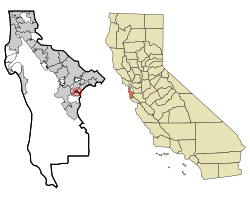
 Location in San Mateo County and the state of California | |
| Coordinates: 37°26′1″N 122°12′11″W / 37.43361°N 122.20306°W | |
| Country | United States |
| State | California |
| County | San Mateo |
| Area | |
• Total | 0.486 sq mi (1.259 km2) |
| • Land | 0.486 sq mi (1.259 km2) |
| • Water | 0 sq mi (0 km2) 0% |
| Elevation | 112 ft (34 m) |
| Population (2020) | |
• Total | 3,930 |
| • Density | 8,100/sq mi (3,100/km2) |
| Time zone | UTC-8 (PST) |
| • Summer (DST) | UTC-7 (PDT) |
| ZIP code | 94025 |
| Area code | 650 |
| FIPS code | 06-84536 |
| GNIS feature ID | 1867071 |
West Menlo Park is a census-designated place and an Unincorporated community in San Mateo County, California, located between the majority of City of Menlo Park, the Town of Atherton, the Sharon Heights neighborhood of Menlo Park and Stanford University (in Santa Clara County). As of the 2020 census, the community had a population of 3,930.
The area consists of suburban housing and a small business district along Alameda de las Pulgas (literally, "Avenue of the Fleas"), often just referred to as "the Alameda", which extends the length of the Rancho de las Pulgas land granted to the Argüello family. West Menlo Park is served by the Las Lomitas School District and Menlo Park Fire District.
Previous Page Next Page


