Our website is made possible by displaying online advertisements to our visitors.
Please consider supporting us by disabling your ad blocker.
Western Siberia
This article needs additional citations for verification. (November 2024) |

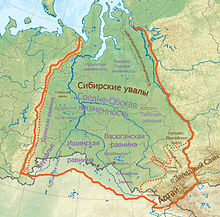
Western Siberia or West Siberia (Russian: Западная Сибирь, IPA: [ˈzapədnəjə sʲɪˈbʲirʲ]; Kazakh: Batys Sıbır, IPA: [bɑˈtə̥s sɘˈbɘr]) is a region in North Asia. It is part of the wider region of Siberia that is mostly located in the Russian Federation, with a Southern part in Kazakhstan. It lies between the Ural region and the Yenisei River, which conventionally divides Siberia into two halves.
Western Siberia covers an area of 2,500,000 square kilometers (970,000 sq mi), nearly 80% of which is located within the West Siberian Plain. The largest rivers of the region are the Irtysh and the Ob.[1] All major rivers of Western Siberia belong to the Kara Sea basin.
The West Siberian petroleum basin is the largest hydrocarbon (petroleum and natural gas) basin in the world covering an area of about 2.2 million km2, and is also the largest oil and gas producing region in Russia.[2]
In medieval times, parts of the region were part of the Golden Horde. After its gradual decline during the 15th century, the Khanate of Sibir, centered on Tyumen, was formed within the area. In the late 16th century, most of Western Siberia was conquered by the Russian Empire, while its southern region became part of the Kazakh Khanate. The current international borders between Russia and Kazakhstan came into being in the late 20th century following the dissolution of the Soviet Union.
- ^ "Western Siberia". Geographical encyclopedia.
- ^ Ulmishek, Gregory F. "West Siberian Oil Basin". PetroNeft Resources Plc. Retrieved 29 January 2022.
Previous Page Next Page


