Our website is made possible by displaying online advertisements to our visitors.
Please consider supporting us by disabling your ad blocker.
Westville, Indiana
Westville, Indiana | |
|---|---|
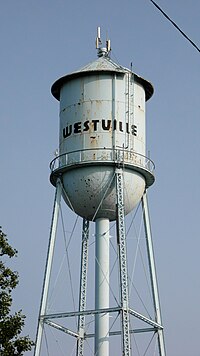
 Westville, Indiana water tower, built in the 1930s | |
| Motto: Community of Progress | |
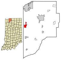
 Location of Westville in LaPorte County, Indiana. | |
| Coordinates: 41°32′15″N 86°54′18″W / 41.53750°N 86.90500°W | |
| Country | United States |
| State | Indiana |
| County | LaPorte |
| Township | New Durham |
| Area | |
• Total | 3.25 sq mi (8.42 km2) |
| • Land | 3.25 sq mi (8.42 km2) |
| • Water | 0.00 sq mi (0.00 km2) |
| Elevation | 774 ft (236 m) |
| Population (2020) | |
• Total | 5,257 |
| • Density | 1,617.04/sq mi (624.34/km2) |
| Time zone | UTC-6 (Central (CST)) |
| • Summer (DST) | UTC-5 (CDT) |
| ZIP code | 46391 |
| Area code | 219 |
| FIPS code | 18-83420[3] |
| GNIS feature ID | 2397737[2] |
| Website | http://www.westville.us |
Westville is a town in New Durham Township, LaPorte County, Indiana, United States. The population, as of the 2020 census is 5,257. It is included in the Michigan City, Indiana-La Porte, Indiana Metropolitan Statistical Area. Westville is located in Northwest Indiana, also known as The Region.
- ^ "2020 U.S. Gazetteer Files". United States Census Bureau. Retrieved March 16, 2022.
- ^ a b U.S. Geological Survey Geographic Names Information System: Westville, Indiana
- ^ "U.S. Census website". United States Census Bureau. Retrieved January 31, 2008.
Previous Page Next Page


