Our website is made possible by displaying online advertisements to our visitors.
Please consider supporting us by disabling your ad blocker.
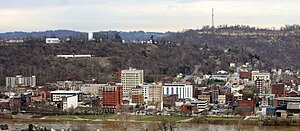
Wheeling metropolitan area
Greater Wheeling | |
|---|---|
| Wheeling, WV–OH Metropolitan Statistical Area | |
 Downtown Wheeling | |
 | |
| Country | |
| State | |
| Largest city | Wheeling |
| Population | |
• Total | 141,254 |
| • Rank | 290th in the U.S. |
| Time zone | UTC−5 (EST) |
| • Summer (DST) | UTC−4 (EDT) |
The Wheeling, WV–OH Metropolitan Statistical Area, as defined by the United States Census Bureau, is an area consisting of two counties in the Northern Panhandle of West Virginia and one in eastern Ohio, anchored by the city of Wheeling. As of the 2010 census, the MSA had a population of 147,950. This represents a decline of 3.4% from the 2000 census population of 153,172.[2]
Greater Wheeling is generally considered part of the Pittsburgh Tri-State area, as the area is heavily influenced by Pittsburgh media and transportation (notably Pittsburgh International Airport), as well as some Ohio media and sports influence.
- ^ United States Census
- ^ "CPH-T-5. Population Change for Metropolitan and Micropolitan Statistical Areas in the United States and Puerto Rico (February 2013 Delineations): 2000 to 2010" (PDF). 2010 Census Population and Housing Tables. United States Census Bureau, Population Division. March 2013. Archived (PDF) from the original on October 2, 2013. Retrieved February 12, 2014.
Previous Page Next Page


