Our website is made possible by displaying online advertisements to our visitors.
Please consider supporting us by disabling your ad blocker.
Wikipedia:WikiProject Nottinghamshire
| This is a WikiProject, an area for focused collaboration among Wikipedians. New participants are welcome; please feel free to participate!
|
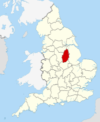
Nottinghamshire | |
|---|---|
| Motto(s): Sapienter proficiens (Progress with wisdom) | |
 | |
| Sovereign state | United Kingdom |
| Constituent country | England |
| Region | East Midlands |
| Established | Historic |
| Time zone | UTC+0 (GMT) |
| • Summer (DST) | UTC+1 (BST) |
| UK Parliament | |
| Police | Nottinghamshire Police |
| Ceremonial county | |
| Lord Lieutenant | Sir John Peace |
| High Sheriff | Col David R Sneath |
| Area | 2,159 km2 (834 sq mi) |
| • Rank | 27th of 48 |
| Population (2022)[1] | 1,163,335 |
| • Rank | 15th of 48 |
| Density | 539/km2 (1,400/sq mi) |
| Ethnicity | 94.1% White British/Irish/Other 2.5% South Asian 1.5% Afro-Caribbean |
| Non-metropolitan county | |
| County council |  Nottinghamshire County Council Nottinghamshire County Council |
| Control | |
| Admin HQ | West Bridgford |
| Area | Error in convert: Needs the number to be converted (help) |
| • Rank | of 21 |
| • Rank | of 21 |
| Density | Error in convert: Needs the number to be converted (help) |
| ISO 3166-2 | GB-NTT |
| ITL | UKF15/16 |
| Website | www |
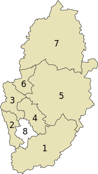
| Districts | |
 Districts of Nottinghamshire | |
| Districts | |
This project is still under-developed.
Please help by expanding it and adding yourself to the members list.
Welcome to the Nottinghamshire WikiProject, a collaboration area and group of editors dedicated to improving Wikipedia's coverage Nottinghamshire, in England.
- ^ "Mid-2022 population estimates by Lieutenancy areas (as at 1997) for England and Wales". Office for National Statistics. 24 June 2024. Retrieved 26 June 2024.
Previous Page Next Page


