Our website is made possible by displaying online advertisements to our visitors.
Please consider supporting us by disabling your ad blocker.
Wiltshire
Wiltshire | |
|---|---|
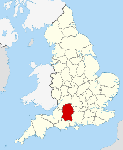
 Wiltshire within England | |
| Coordinates: 51°18′N 1°54′W / 51.3°N 01.9°W | |
| Sovereign state | United Kingdom |
| Constituent country | England |
| Region | South West |
| Established | Ancient |
| Time zone | UTC+0 (GMT) |
| • Summer (DST) | UTC+1 (BST) |
| UK Parliament | List of MPs |
| Police | Wiltshire Police |
| Ceremonial county | |
| Lord Lieutenant | Sarah Troughton |
| Area | 3,485 km2 (1,346 sq mi) |
| • Rank | 14th of 48 |
| Population (2022)[1] | 751,542 |
| • Rank | 34th of 48 |
| Density | 216/km2 (560/sq mi) |
| Unitary authorities | |
| Councils | Wiltshire Council Swindon Borough Council |
| Districts | |
 Districts of Wiltshire Unitary | |
| Districts | |
Wiltshire (/ˈwɪlt.ʃər, -ʃɪr/;[2] abbreviated to Wilts) is a ceremonial county in South West England. It borders Gloucestershire to the north, Oxfordshire to the north-east, Berkshire to the east, Hampshire to the south-east, Dorset to the south, and Somerset to the west. The largest settlement is Swindon, and Trowbridge is the county town.
The county has an area of 3,485 km2 (1,346 square miles) and a population of 720,060. The county is mostly rural, and the centre and south-west are sparsely populated. After Swindon (183,638), the largest settlements are the city of Salisbury (41,820) and the towns of Chippenham (37,548) and Trowbridge (37,169). For local government purposes, the county comprises two unitary authority areas: Swindon and Wiltshire.
Undulating chalk downlands characterize much of the county. In the east are Marlborough Downs, which contain Savernake Forest. To the south is the Vale of Pewsey, which separates the downs from Salisbury Plain in the centre of the county. The south-west is also downland, and contains the West Wiltshire Downs, the Vale of Wardour to their south, and part of Cranborne Chase in the far south of the county. The north-west of Wiltshire is part of the Cotswolds, a limestone area. The county's two major rivers are both called the Avon; the northern Avon enters the county in the north-west and flows in a south-westerly direction before leaving it near Bradford-on-Avon, and the southern Avon rises on Salisbury Plain and flows through Salisbury, then into Hampshire. The far south-east contains part of the New Forest. Much of the county is protected: the Marlborough Downs; West Wiltshire Downs, Vale of Wardour, and Cranbourne Chase; and the Cotswolds are all part of designated national landscapes, and the New Forest is a national park.
Salisbury Plain is noted for the Stonehenge and Avebury stone circles, which together are a UNESCO World Heritage Site, and other ancient landmarks. Much of the plain is a training area for the British Army. The city of Salisbury is notable for its medieval cathedral. Large country houses open to the public include Longleat, where there is also a safari park, and the National Trust's Stourhead.
- ^ "Mid-2022 population estimates by Lieutenancy areas (as at 1997) for England and Wales". Office for National Statistics. 24 June 2024. Retrieved 26 June 2024.
- ^ "Wiltshire". Collins Dictionary. Archived from the original on 24 September 2014. Retrieved 23 September 2014.
Previous Page Next Page


